Chetilla geodata
Chetilla (Cajamarca) is a seat of a third-order administrative division; located in Peru in America/Lima (GMT-5) time zone. In our database, there are 305 cities with bigger population. Compared to other cities in Peru, 78.3% of cities are located further ↓South; 87.3% of cities are located further →East and 51.2% of cities have lower elevation than Chetilla. Note1


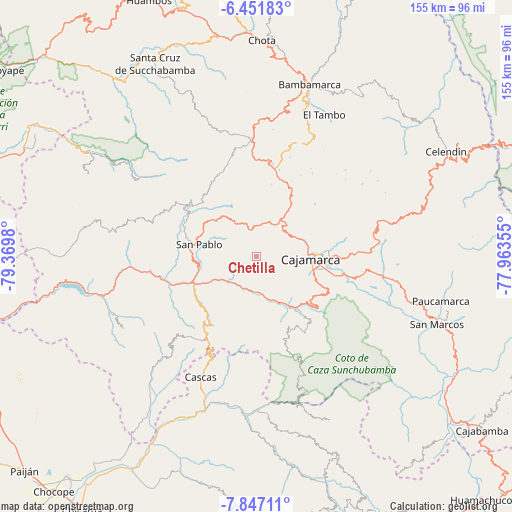
Chetilla GPS coordinates[2]
7° 9' 0" South, 78° 40' 0.012" West
| Map corner | latitude | longitude |
|---|---|---|
| Upper-left | -6.45183°, | -79.3698° |
| Center: | -7.15°, | -78.66667° |
| Lower-right: | -7.84711°, | -77.96355° |
| Map W x H: | 155.1×155.1 km | = 96.4×96.4mi |
| max Lat: | -0.96667° ⇑21.7% North |
| Chetilla: | -7.15° |
| min Lat: | ⇓78.3% South -18.01465° |
| min Long | Chetilla | max Long |
| -81.30472° | -78.66667° | -69.04167° |
| W 12.7%⇐ | ⇒87.3% E |
Elevation
Elevation of Chetilla is 2895 m = 9498 ft, and this is 576.3 m = 1891 ft above average elevation for this country.
| Max E: |
5022 m = 16476 ft | 48.8% |
| Chetilla | 2895 m 9498 ft | |
| Avg. | 2318.7 m = 7607 ft | |
Min E: |
1 m = 3 ft | 51.2% |
See also: Peru elevation on elevation.city.
Geographical zone
Chetilla is located in South Torrid zone (between Equator and Tropic of Capricorn). Distance of Equator is 795 km =494 mi to North.| Distance of | km | miles | from Chetilla |
|---|---|---|---|
| Equator | 795 | 494 | to North |
| Tropic Capricorn | 1810.9 | 1125.2 | to South |
| Antarctic Circle | 6606.2 | 4104.9 | to South |
| South Pole | 9212.1 | 5724.1 | to South |


Nearby cities:
15 places around Chetilla: (largest is in red/bold)
• Cajamarca
18.4 km =11.4 mi,  94°
94°
• Cascas
40.6 km =25.2 mi,  204°
204°
• Chilete
22.2 km =13.8 mi,  245°
245°
• El Prado
39 km =24.2 mi,  289°
289°
• Encañada
35.7 km =22.2 mi,  78°
78°
• Guzmango
36.5 km =22.7 mi,  224°
224°
• Hualgayoc
43 km =26.7 mi,  7°
7°
• Llacanora
26.3 km =16.3 mi,  102°
102°
• Llapa
24.8 km =15.4 mi,  318°
318°
• Magdalena
11.1 km =6.9 mi,  180°
180°
• Namora
37.2 km =23.1 mi, 98°
• San Benito
43.1 km =26.8 mi, 223°
• San Bernardino
18.8 km =11.7 mi,  258°
258°
• San Juan
24.8 km =15.4 mi,  132°
132°
• San Pablo
18.8 km =11.7 mi,  281°
281°
Sources, notices
• [Note1] Compared only with cities in Peru existing in our database
• [Src1] Map data: © OpenStreetMap contributors (CC-BY-SA)
• [Src2] Other city data from geonames.org with taken over terms of usage.
• [Src3] Geographical zone / Annual Mean Temperature by Robert A. Rohde @ Wikipedia
