Chilete geodata
Chilete (Cajamarca) is a seat of a third-order administrative division; located in Peru in America/Lima (GMT-5) time zone. In our database, there are 305 cities with bigger population. Compared to other cities in Peru, 77.4% of cities are located further ↓South; 88.9% of cities are located further →East and 71.7% of cities have higher elevation than Chilete. Note1


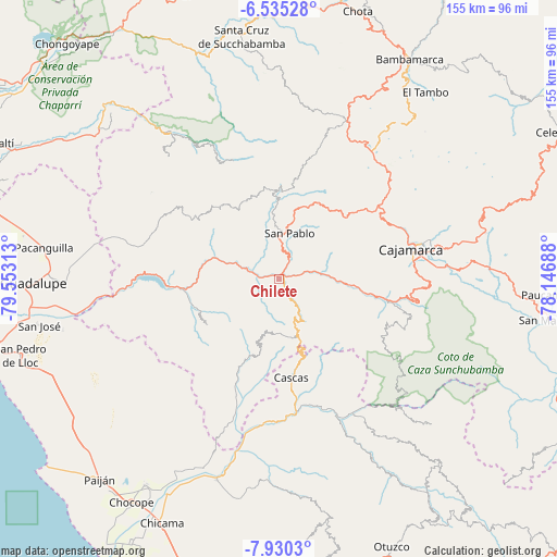
Chilete GPS coordinates[2]
7° 13' 59.988" South, 78° 51' 0" West
| Map corner | latitude | longitude |
|---|---|---|
| Upper-left | -6.53528°, | -79.55313° |
| Center: | -7.23333°, | -78.85° |
| Lower-right: | -7.9303°, | -78.14688° |
| Map W x H: | 155.1×155.1 km | = 96.4×96.4mi |
| max Lat: | -0.96667° ⇑22.6% North |
| Chilete: | -7.23333° |
| min Lat: | ⇓77.4% South -18.01465° |
| min Long | Chilete | max Long |
| -81.30472° | -78.85° | -69.04167° |
| W 11.1%⇐ | ⇒88.9% E |
Elevation
Elevation of Chilete is 1137 m = 3730 ft, and this is 1181.7 m = 3877 ft below average elevation for this country.
| Max E: |
5022 m = 16476 ft | 71.7% |
| Avg. | 2318.7 m = 7607 ft | |
| Chilete | 1137 m = 3730 ft | |
Min E: |
1 m = 3 ft | 28.3% |
See also: Peru elevation on elevation.city.
Geographical zone
Chilete is located in South Torrid zone (between Equator and Tropic of Capricorn). Distance of Equator is 804.3 km =499.8 mi to North.| Distance of | km | miles | from Chilete |
|---|---|---|---|
| Equator | 804.3 | 499.8 | to North |
| Tropic Capricorn | 1801.6 | 1119.5 | to South |
| Antarctic Circle | 6596.9 | 4099.1 | to South |
| South Pole | 9202.8 | 5718.4 | to South |


Nearby cities:
15 places around Chilete: (largest is in red/bold)
• Cajamarca
39.3 km =24.4 mi,  78°
78°
• Cascas
28 km =17.4 mi,  172°
172°
• Chetilla
22.2 km =13.8 mi,  65°
65°
• El Prado
27.7 km =17.2 mi,  323°
323°
• Guzmango
17.6 km =10.9 mi,  198°
198°
• Llapa
28 km =17.4 mi,  7°
7°
• Magdalena
20.3 km =12.6 mi,  95°
95°
• Niepos
45.9 km =28.5 mi, 317°
• San Benito
24.1 km =15 mi, 202°
• San Bernardino
5.9 km =3.7 mi,  18°
18°
• San Gregorio
34.3 km =21.3 mi,  306°
306°
• San Juan
39.3 km =24.4 mi, 100°
• San Pablo
13.1 km =8.1 mi, 8°
• Tembladera
33.3 km =20.7 mi,  263°
263°
• Trinidad
24 km =14.9 mi,  237°
237°
Sources, notices
• [Note1] Compared only with cities in Peru existing in our database
• [Src1] Map data: © OpenStreetMap contributors (CC-BY-SA)
• [Src2] Other city data from geonames.org with taken over terms of usage.
• [Src3] Geographical zone / Annual Mean Temperature by Robert A. Rohde @ Wikipedia
