San Juan geodata
San Juan (Cajamarca) is a seat of a third-order administrative division; located in Peru in America/Lima (GMT-5) time zone. In our database, there are 305 cities with bigger population. Compared to other cities in Peru, 77.1% of cities are located further ↓South; 85.7% of cities are located further →East and 64.7% of cities have higher elevation than San Juan. Note1


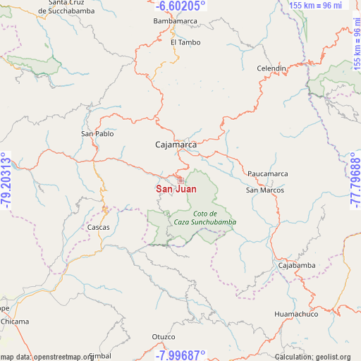
San Juan GPS coordinates[2]
7° 18' 0" South, 78° 30' 0" West
| Map corner | latitude | longitude |
|---|---|---|
| Upper-left | -6.60205°, | -79.20313° |
| Center: | -7.3°, | -78.5° |
| Lower-right: | -7.99687°, | -77.79688° |
| Map W x H: | 155.1×155.1 km | = 96.4×96.4mi |
| max Lat: | -0.96667° ⇑22.9% North |
| San Juan: | -7.3° |
| min Lat: | ⇓77.1% South -18.01465° |
| min Long | San Juan | max Long |
| -81.30472° | -78.5° | -69.04167° |
| W 14.3%⇐ | ⇒85.7% E |
Elevation
Elevation of San Juan is 2075 m = 6808 ft, and this is 243.7 m = 800 ft below average elevation for this country.
| Max E: |
5022 m = 16476 ft | 64.7% |
| Avg. | 2318.7 m = 7607 ft | |
| San Juan | 2075 m = 6808 ft | |
Min E: |
1 m = 3 ft | 35.3% |
See also: Peru elevation on elevation.city.
Geographical zone
San Juan is located in South Torrid zone (between Equator and Tropic of Capricorn). Distance of Equator is 811.7 km =504.4 mi to North.| Distance of | km | miles | from San Juan |
|---|---|---|---|
| Equator | 811.7 | 504.4 | to North |
| Tropic Capricorn | 1794.2 | 1114.9 | to South |
| Antarctic Circle | 6589.5 | 4094.5 | to South |
| South Pole | 9195.4 | 5713.8 | to South |


Nearby cities:
15 places around San Juan: (largest is in red/bold)
• Cachachi
29.1 km =18.1 mi,  124°
124°
• Cajamarca
15.1 km =9.4 mi,  359°
359°
• Cascas
40.4 km =25.1 mi,  239°
239°
• Chetilla
24.8 km =15.4 mi,  312°
312°
• Chilete
39.3 km =24.4 mi,  280°
280°
• Encañada
29.2 km =18.1 mi,  34°
34°
• Huaranchal
43 km =26.7 mi,  172°
172°
• Llacanora
13.3 km =8.3 mi, 33°
• Lucma
37.5 km =23.3 mi,  188°
188°
• Magdalena
19.2 km =11.9 mi,  286°
286°
• Namora
21.5 km =13.4 mi,  58°
58°
• San Bernardino
39 km =24.2 mi, 289°
• San Marcos
35.1 km =21.8 mi,  96°
96°
• San Pablo
42 km =26.1 mi,  299°
299°
• Sayapullo
33.6 km =20.9 mi, 173°
Sources, notices
• [Note1] Compared only with cities in Peru existing in our database
• [Src1] Map data: © OpenStreetMap contributors (CC-BY-SA)
• [Src2] Other city data from geonames.org with taken over terms of usage.
• [Src3] Geographical zone / Annual Mean Temperature by Robert A. Rohde @ Wikipedia
