Cascas geodata
Cascas (La Libertad) is a seat of a third-order administrative division; located in Peru in America/Lima (GMT-5) time zone. With population of 4,299 people, there are 258 cities with bigger population in this country. Compared to other cities in Peru, 76.2% of cities are located further ↓South; 88.6% of cities are located further →East and 71.1% of cities have higher elevation than Cascas. Note1


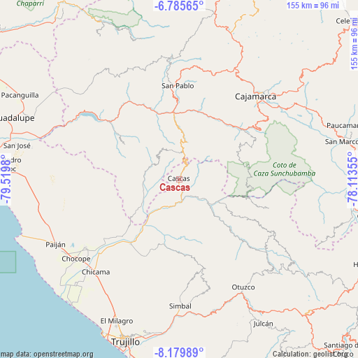
Cascas GPS coordinates[2]
7° 28' 59.988" South, 78° 49' 0.012" West
| Map corner | latitude | longitude |
|---|---|---|
| Upper-left | -6.78565°, | -79.5198° |
| Center: | -7.48333°, | -78.81667° |
| Lower-right: | -8.17989°, | -78.11355° |
| Map W x H: | 155×155 km | = 96.3×96.3mi |
| max Lat: | -0.96667° ⇑23.8% North |
| Cascas: | -7.48333° |
| min Lat: | ⇓76.2% South -18.01465° |
| min Long | Cascas | max Long |
| -81.30472° | -78.81667° | -69.04167° |
| W 11.4%⇐ | ⇒88.6% E |
Elevation
Elevation of Cascas is 1236 m = 4055 ft, and this is 1082.7 m = 3552 ft below average elevation for this country.
| Max E: |
5022 m = 16476 ft | 71.1% |
| Avg. | 2318.7 m = 7607 ft | |
| Cascas | 1236 m = 4055 ft | |
Min E: |
1 m = 3 ft | 28.9% |
See also: Peru elevation on elevation.city.
Geographical zone
Cascas is located in South Torrid zone (between Equator and Tropic of Capricorn). Distance of Equator is 832.1 km =517 mi to North.| Distance of | km | miles | from Cascas |
|---|---|---|---|
| Equator | 832.1 | 517 | to North |
| Tropic Capricorn | 1773.9 | 1102.3 | to South |
| Antarctic Circle | 6569.1 | 4081.8 | to South |
| South Pole | 9175 | 5701.1 | to South |


Nearby cities:
15 places around Cascas: (largest is in red/bold)
• Ascope
41.1 km =25.5 mi,  231°
231°
• Chetilla
40.6 km =25.2 mi,  24°
24°
• Chilete
28 km =17.4 mi,  352°
352°
• Guzmango
14.4 km =8.9 mi,  320°
320°
• Huaranchal
46.1 km =28.6 mi,  118°
118°
• Lucma
33.8 km =21 mi, 119°
• Magdalena
30.8 km =19.1 mi,  32°
32°
• San Benito
14 km =8.7 mi,  293°
293°
• San Bernardino
33.4 km =20.8 mi,  356°
356°
• San Juan
40.4 km =25.1 mi,  59°
59°
• San Pablo
40.8 km =25.4 mi, 357°
• Sayapullo
40.7 km =25.3 mi,  108°
108°
• Sinsicap
39.3 km =24.4 mi,  171°
171°
• Tembladera
43.9 km =27.3 mi,  303°
303°
• Trinidad
28.1 km =17.5 mi, 301°
Sources, notices
• [Note1] Compared only with cities in Peru existing in our database
• [Src1] Map data: © OpenStreetMap contributors (CC-BY-SA)
• [Src2] Other city data from geonames.org with taken over terms of usage.
• [Src3] Geographical zone / Annual Mean Temperature by Robert A. Rohde @ Wikipedia
