Chalaco geodata
Chalaco (Piura) is a seat of a third-order administrative division; located in Peru in America/Lima (GMT-5) time zone. In our database, there are 305 cities with bigger population. Compared to other cities in Peru, 95.3% of cities are located further ↓South; 94.7% of cities are located further →East and 62.7% of cities have higher elevation than Chalaco. Note1


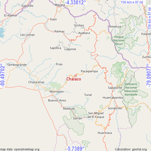
Chalaco GPS coordinates[2]
5° 2' 20.004" South, 79° 47' 38.004" West
| Map corner | latitude | longitude |
|---|---|---|
| Upper-left | -4.33812°, | -80.49702° |
| Center: | -5.03889°, | -79.79389° |
| Lower-right: | -5.7389°, | -79.09077° |
| Map W x H: | 155.8×155.8 km | = 96.8×96.8mi |
| max Lat: | -0.96667° ⇑4.7% North |
| Chalaco: | -5.03889° |
| min Lat: | ⇓95.3% South -18.01465° |
| min Long | Chalaco | max Long |
| -81.30472° | -79.79389° | -69.04167° |
| W 5.3%⇐ | ⇒94.7% E |
Elevation
Elevation of Chalaco is 2260 m = 7415 ft, and this is 58.7 m = 193 ft below average elevation for this country.
| Max E: |
5022 m = 16476 ft | 62.7% |
| Avg. | 2318.7 m = 7607 ft | |
| Chalaco | 2260 m = 7415 ft | |
Min E: |
1 m = 3 ft | 37.3% |
See also: Peru elevation on elevation.city.
Geographical zone
Chalaco is located in South Torrid zone (between Equator and Tropic of Capricorn). Distance of Equator is 560.3 km =348.2 mi to North.| Distance of | km | miles | from Chalaco |
|---|---|---|---|
| Equator | 560.3 | 348.2 | to North |
| Tropic Capricorn | 2045.6 | 1271.1 | to South |
| Antarctic Circle | 6840.9 | 4250.7 | to South |
| South Pole | 9446.8 | 5870 | to South |


Nearby cities:
15 places around Chalaco: (largest is in red/bold)
• Ayabaca
45.2 km =28.1 mi,  11°
11°
• Buenos Aires
31.1 km =19.3 mi,  217°
217°
• Canchaque
42.9 km =26.7 mi,  150°
150°
• Chulucanas
41.3 km =25.7 mi,  261°
261°
• Frias
21 km =13 mi,  305°
305°
• Huancabamba
44 km =27.3 mi,  120°
120°
• Lagunas
28.3 km =17.6 mi,  348°
348°
• Morropón
25.6 km =15.9 mi,  229°
229°
• Pacaipampa
14.8 km =9.2 mi,  70°
70°
• Paltashaco
12 km =7.5 mi,  235°
235°
• Santo Domingo
9 km =5.6 mi,  279°
279°
• Sapalache
41.7 km =25.9 mi,  107°
107°
• Sapillica
35.7 km =22.2 mi,  324°
324°
• Tunal
23 km =14.3 mi, 145°
• Yamango
16.2 km =10.1 mi,  162°
162°
Sources, notices
• [Note1] Compared only with cities in Peru existing in our database
• [Src1] Map data: © OpenStreetMap contributors (CC-BY-SA)
• [Src2] Other city data from geonames.org with taken over terms of usage.
• [Src3] Geographical zone / Annual Mean Temperature by Robert A. Rohde @ Wikipedia
