Ayabaca geodata
Ayabaca (Piura) is a seat of a third-order administrative division; located in Peru in America/Lima (GMT-5) time zone. With population of 5,270 people, there are 230 cities with bigger population in this country. Compared to other cities in Peru, 97.2% of cities are located further ↓South; 94.2% of cities are located further →East and 54.2% of cities have higher elevation than Ayabaca. Note1


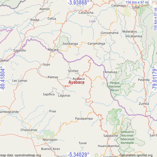
Ayabaca GPS coordinates[2]
4° 38' 23.388" South, 79° 42' 53.676" West
| Map corner | latitude | longitude |
|---|---|---|
| Upper-left | -3.93868°, | -80.41804° |
| Center: | -4.63983°, | -79.71491° |
| Lower-right: | -5.34029°, | -79.01179° |
| Map W x H: | 155.8×155.8 km | = 96.8×96.8mi |
| max Lat: | -0.96667° ⇑2.8% North |
| Ayabaca: | -4.63983° |
| min Lat: | ⇓97.2% South -18.01465° |
| min Long | Ayabaca | max Long |
| -81.30472° | -79.71491° | -69.04167° |
| W 5.8%⇐ | ⇒94.2% E |
Elevation
Elevation of Ayabaca is 2715 m = 8907 ft, and this is 396.3 m = 1300 ft above average elevation for this country.
| Max E: |
5022 m = 16476 ft | 54.2% |
| Ayabaca | 2715 m 8907 ft | |
| Avg. | 2318.7 m = 7607 ft | |
Min E: |
1 m = 3 ft | 45.8% |
See also: Peru elevation on elevation.city.
Geographical zone
Ayabaca is located in South Torrid zone (between Equator and Tropic of Capricorn). Distance of Equator is 515.9 km =320.6 mi to North.| Distance of | km | miles | from Ayabaca |
|---|---|---|---|
| Equator | 515.9 | 320.6 | to North |
| Tropic Capricorn | 2090 | 1298.7 | to South |
| Antarctic Circle | 6885.3 | 4278.3 | to South |
| South Pole | 9491.2 | 5897.6 | to South |


Nearby cities:
15 places around Ayabaca: (largest is in red/bold)
• Chalaco
45.2 km =28.1 mi,  191°
191°
• Frias
41.3 km =25.7 mi,  218°
218°
• Jilili
11.1 km =6.9 mi,  304°
304°
• Lagunas
22 km =13.7 mi, 220°
• Las Lomas
59 km =36.7 mi,  268°
268°
• Montero
12.6 km =7.8 mi, 274°
• Pacaipampa
39.8 km =24.7 mi,  172°
172°
• Paimas
25.5 km =15.8 mi, 273°
• Paltashaco
54.4 km =33.8 mi,  200°
200°
• Santo Domingo
46.4 km =28.8 mi, 202°
• Sapalache
64.8 km =40.3 mi,  151°
151°
• Sapillica
33.4 km =20.8 mi,  242°
242°
• Suyo
34.9 km =21.7 mi,  293°
293°
• Tunal
63.5 km =39.5 mi,  176°
176°
• Yamango
59.9 km =37.2 mi, 183°
Sources, notices
• [Note1] Compared only with cities in Peru existing in our database
• [Src1] Map data: © OpenStreetMap contributors (CC-BY-SA)
• [Src2] Other city data from geonames.org with taken over terms of usage.
• [Src3] Geographical zone / Annual Mean Temperature by Robert A. Rohde @ Wikipedia
