Lagunas geodata
Lagunas (Piura) is a seat of a third-order administrative division; located in Peru in America/Lima (GMT-5) time zone. In our database, there are 305 cities with bigger population. Compared to other cities in Peru, 96.8% of cities are located further ↓South; 95.4% of cities are located further →East and 63.6% of cities have higher elevation than Lagunas. Note1


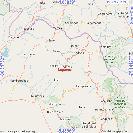
Lagunas GPS coordinates[2]
4° 47' 21.84" South, 79° 50' 39.804" West
| Map corner | latitude | longitude |
|---|---|---|
| Upper-left | -4.08839°, | -80.54752° |
| Center: | -4.7894°, | -79.84439° |
| Lower-right: | -5.48969°, | -79.14127° |
| Map W x H: | 155.8×155.8 km | = 96.8×96.8mi |
| max Lat: | -0.96667° ⇑3.2% North |
| Lagunas: | -4.7894° |
| min Lat: | ⇓96.8% South -18.01465° |
| min Long | Lagunas | max Long |
| -81.30472° | -79.84439° | -69.04167° |
| W 4.6%⇐ | ⇒95.4% E |
Elevation
Elevation of Lagunas is 2176 m = 7139 ft, and this is 142.7 m = 468 ft below average elevation for this country.
| Max E: |
5022 m = 16476 ft | 63.6% |
| Avg. | 2318.7 m = 7607 ft | |
| Lagunas | 2176 m = 7139 ft | |
Min E: |
1 m = 3 ft | 36.4% |
See also: Peru elevation on elevation.city.
Geographical zone
Lagunas is located in South Torrid zone (between Equator and Tropic of Capricorn). Distance of Equator is 532.5 km =330.9 mi to North.| Distance of | km | miles | from Lagunas |
|---|---|---|---|
| Equator | 532.5 | 330.9 | to North |
| Tropic Capricorn | 2073.4 | 1288.4 | to South |
| Antarctic Circle | 6868.6 | 4267.9 | to South |
| South Pole | 9474.5 | 5887.2 | to South |


Nearby cities:
15 places around Lagunas: (largest is in red/bold)
• Ayabaca
22 km =13.7 mi,  40°
40°
• Chalaco
28.3 km =17.6 mi,  168°
168°
• Chulucanas
48.8 km =30.3 mi,  226°
226°
• Frias
19.4 km =12.1 mi,  216°
216°
• Jilili
23.6 km =14.7 mi,  12°
12°
• Las Lomas
47.1 km =29.3 mi,  288°
288°
• Montero
17.7 km =11 mi, 5°
• Morropón
46.4 km =28.8 mi,  197°
197°
• Pacaipampa
30.1 km =18.7 mi,  139°
139°
• Paimas
21.2 km =13.2 mi,  328°
328°
• Paltashaco
34.8 km =21.6 mi,  187°
187°
• Santo Domingo
26.5 km =16.5 mi, 187°
• Sapillica
15.4 km =9.6 mi,  274°
274°
• Suyo
35.3 km =21.9 mi, 330°
• Yamango
44.4 km =27.6 mi, 166°
Sources, notices
• [Note1] Compared only with cities in Peru existing in our database
• [Src1] Map data: © OpenStreetMap contributors (CC-BY-SA)
• [Src2] Other city data from geonames.org with taken over terms of usage.
• [Src3] Geographical zone / Annual Mean Temperature by Robert A. Rohde @ Wikipedia
