Chuquibamba geodata
Chuquibamba (Amazonas) is a seat of a third-order administrative division; located in Peru in America/Lima (GMT-5) time zone. In our database, there are 305 cities with bigger population. Compared to other cities in Peru, 80% of cities are located further ↓South; 78.4% of cities are located further →East and 50.6% of cities have higher elevation than Chuquibamba. Note1
Administrative division(s):
- Level 1: Amazonas
- Level 2: Provincia de Chachapoyas
- Level 3: Chuquibamba


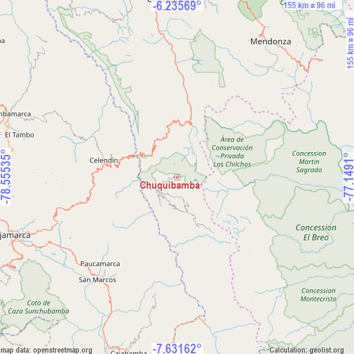
Chuquibamba GPS coordinates[2]
6° 56' 3.012" South, 77° 51' 7.992" West
| Map corner | latitude | longitude |
|---|---|---|
| Upper-left | -6.23569°, | -78.55535° |
| Center: | -6.93417°, | -77.85222° |
| Lower-right: | -7.63162°, | -77.1491° |
| Map W x H: | 155.2×155.2 km | = 96.4×96.4mi |
| max Lat: | -0.96667° ⇑20% North |
| Chuquibamba: | -6.93417° |
| min Lat: | ⇓80% South -18.01465° |
| min Long | Chuquibamba | max Long |
| -81.30472° | -77.85222° | -69.04167° |
| W 21.6%⇐ | ⇒78.4% E |
Elevation
Elevation of Chuquibamba is 2825 m = 9268 ft, and this is 506.3 m = 1661 ft above average elevation for this country.
| Max E: |
5022 m = 16476 ft | 50.6% |
| Chuquibamba | 2825 m 9268 ft | |
| Avg. | 2318.7 m = 7607 ft | |
Min E: |
1 m = 3 ft | 49.4% |
See also: Peru elevation on elevation.city.
Geographical zone
Chuquibamba is located in South Torrid zone (between Equator and Tropic of Capricorn). Distance of Equator is 771 km =479.1 mi to North.| Distance of | km | miles | from Chuquibamba |
|---|---|---|---|
| Equator | 771 | 479.1 | to North |
| Tropic Capricorn | 1834.9 | 1140.2 | to South |
| Antarctic Circle | 6630.2 | 4119.8 | to South |
| South Pole | 9236.1 | 5739 | to South |


Nearby cities:
15 places around Chuquibamba: (largest is in red/bold)
• Balsas
21.3 km =13.2 mi,  301°
301°
• Bolívar
29.5 km =18.3 mi,  145°
145°
• Celendín
33.3 km =20.7 mi,  283°
283°
• Cocabamba
41.4 km =25.7 mi,  333°
333°
• Duraznopampa
38.2 km =23.7 mi,  7°
7°
• Huacapampa
31 km =19.3 mi,  270°
270°
• La Jalca
50 km =31.1 mi,  4°
4°
• Longotea
16.4 km =10.2 mi,  205°
205°
• Lucmapampa
27.4 km =17 mi, 266°
• Montevideo
35.8 km =22.2 mi, 8°
• Oxamarca
26.1 km =16.2 mi,  245°
245°
• Sorochuco
44.5 km =27.7 mi, 273°
• Sucre
32.9 km =20.4 mi, 270°
• Ucuncha
22.4 km =13.9 mi,  188°
188°
• Utco
21.9 km =13.6 mi, 275°
Sources, notices
• [Note1] Compared only with cities in Peru existing in our database
• [Src1] Map data: © OpenStreetMap contributors (CC-BY-SA)
• [Src2] Other city data from geonames.org with taken over terms of usage.
• [Src3] Geographical zone / Annual Mean Temperature by Robert A. Rohde @ Wikipedia
