Tuti geodata
Tuti (Arequipa) is a seat of a third-order administrative division; located in Peru in America/Lima (GMT-5) time zone. In our database, there are 305 cities with bigger population. Compared to other cities in Peru, 89.6% of cities are located further ↑North; 84.8% of cities are located further ←West and 88.2% of cities have lower elevation than Tuti. Note1


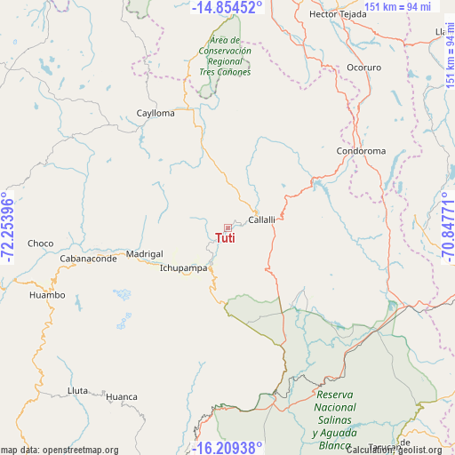
Tuti GPS coordinates[2]
15° 31' 59.016" South, 71° 33' 2.988" West
| Map corner | latitude | longitude |
|---|---|---|
| Upper-left | -14.85452°, | -72.25396° |
| Center: | -15.53306°, | -71.55083° |
| Lower-right: | -16.20938°, | -70.84771° |
| Map W x H: | 150.6×150.6 km | = 93.6×93.6mi |
| max Lat: | -0.96667° ⇑89.6% North |
| Tuti: | -15.53306° |
| min Lat: | ⇓10.4% South -18.01465° |
| min Long | Tuti | max Long |
| -81.30472° | -71.55083° | -69.04167° |
| W 84.8%⇐ | ⇒15.2% E |
Elevation
Elevation of Tuti is 3802 m = 12474 ft, and this is 1483.3 m = 4866 ft above average elevation for this country.
| Max E: |
5022 m = 16476 ft | 11.8% |
| Tuti | 3802 m 12474 ft | |
| Avg. | 2318.7 m = 7607 ft | |
Min E: |
1 m = 3 ft | 88.2% |
See also: Peru elevation on elevation.city.
Geographical zone
Tuti is located in South Torrid zone (between Equator and Tropic of Capricorn). Distance of this Southern Tropic circle is 878.8 km =546.1 mi to South.| Distance of | km | miles | from Tuti |
|---|---|---|---|
| Equator | 1727.1 | 1073.2 | to North |
| Tropic Capricorn | 878.8 | 546.1 | to South |
| Antarctic Circle | 5674.1 | 3525.7 | to South |
| South Pole | 8279.9 | 5144.9 | to South |


Nearby cities:
15 places around Tuti: (largest is in red/bold)
• Achoma
21.4 km =13.3 mi,  228°
228°
• Callalli
11.6 km =7.2 mi,  76°
76°
• Ccolo
7 km =4.3 mi,  64°
64°
• Chivay
12.9 km =8 mi,  204°
204°
• Coporaque
14.6 km =9.1 mi,  224°
224°
• Huarancante
27.9 km =17.3 mi,  159°
159°
• Ichupampa
19.6 km =12.2 mi, 228°
• Jayune
26.7 km =16.6 mi,  97°
97°
• Lari
25.4 km =15.8 mi,  247°
247°
• Llongasora
29.4 km =18.3 mi,  113°
113°
• Maca
26.3 km =16.3 mi,  242°
242°
• Madrigal
28.8 km =17.9 mi, 253°
• Sibayo
11.2 km =7 mi, 62°
• Tisco
23.5 km =14.6 mi,  27°
27°
• Yanque
17.3 km =10.7 mi, 221°
Sources, notices
• [Note1] Compared only with cities in Peru existing in our database
• [Src1] Map data: © OpenStreetMap contributors (CC-BY-SA)
• [Src2] Other city data from geonames.org with taken over terms of usage.
• [Src3] Geographical zone / Annual Mean Temperature by Robert A. Rohde @ Wikipedia
