Huarancante geodata
Huarancante (Arequipa) is a populated place; located in Peru in America/Lima (GMT-5) time zone. With population of 4,638 people, there are 242 cities with bigger population in this country. Compared to other cities in Peru, 92.4% of cities are located further ↑North; 85.8% of cities are located further ←West and 99.5% of cities have lower elevation than Huarancante. Note1


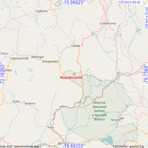
Huarancante GPS coordinates[2]
15° 46' 4.908" South, 71° 27' 34.272" West
| Map corner | latitude | longitude |
|---|---|---|
| Upper-left | -15.09025°, | -72.16265° |
| Center: | -15.76803°, | -71.45952° |
| Lower-right: | -16.44355°, | -70.7564° |
| Map W x H: | 150.5×150.5 km | = 93.5×93.5mi |
| max Lat: | -0.96667° ⇑92.4% North |
| Huarancante: | -15.76803° |
| min Lat: | ⇓7.6% South -18.01465° |
| min Long | Huarancante | max Long |
| -81.30472° | -71.45952° | -69.04167° |
| W 85.8%⇐ | ⇒14.2% E |
Elevation
Elevation of Huarancante is 4587 m = 15049 ft, and this is 2268.3 m = 7442 ft above average elevation for this country.
| Max E: |
5022 m = 16476 ft | 0.5% |
| Huarancante | 4587 m 15049 ft | |
| Avg. | 2318.7 m = 7607 ft | |
Min E: |
1 m = 3 ft | 99.5% |
See also: Peru elevation on elevation.city.
Geographical zone
Huarancante is located in South Torrid zone (between Equator and Tropic of Capricorn). Distance of this Southern Tropic circle is 852.7 km =529.8 mi to South.| Distance of | km | miles | from Huarancante |
|---|---|---|---|
| Equator | 1753.2 | 1089.4 | to North |
| Tropic Capricorn | 852.7 | 529.8 | to South |
| Antarctic Circle | 5647.9 | 3509.4 | to South |
| South Pole | 8253.8 | 5128.7 | to South |


Nearby cities:
15 places around Huarancante: (largest is in red/bold)
• Achoma
28.4 km =17.6 mi,  294°
294°
• Callalli
28.9 km =18 mi,  2°
2°
• Ccolo
29.3 km =18.2 mi,  353°
353°
• Chivay
20.9 km =13 mi,  313°
313°
• Coporaque
25.4 km =15.8 mi, 308°
• Ichupampa
27.7 km =17.2 mi,  298°
298°
• Jatun Orcochiri
12.3 km =7.6 mi,  80°
80°
• Jayune
28.3 km =17.6 mi,  36°
36°
• Llongasora
22.3 km =13.9 mi,  50°
50°
• Maca
36 km =22.4 mi, 292°
• Pucara
23.6 km =14.7 mi,  180°
180°
• Sibayo
31.3 km =19.4 mi, 0°
• Tuti
27.9 km =17.3 mi,  339°
339°
• Vizcachane
28 km =17.4 mi,  99°
99°
• Yanque
25 km =15.5 mi, 301°
Sources, notices
• [Note1] Compared only with cities in Peru existing in our database
• [Src1] Map data: © OpenStreetMap contributors (CC-BY-SA)
• [Src2] Other city data from geonames.org with taken over terms of usage.
• [Src3] Geographical zone / Annual Mean Temperature by Robert A. Rohde @ Wikipedia
