Madrigal geodata
Madrigal (Arequipa) is a seat of a third-order administrative division; located in Peru in America/Lima (GMT-5) time zone. In our database, there are 305 cities with bigger population. Compared to other cities in Peru, 90.2% of cities are located further ↑North; 82.4% of cities are located further ←West and 66.3% of cities have lower elevation than Madrigal. Note1


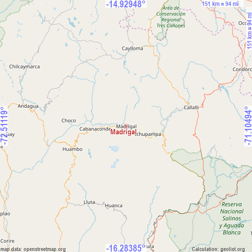
Madrigal GPS coordinates[2]
15° 36' 28.008" South, 71° 48' 29.016" West
| Map corner | latitude | longitude |
|---|---|---|
| Upper-left | -14.92948°, | -72.51119° |
| Center: | -15.60778°, | -71.80806° |
| Lower-right: | -16.28385°, | -71.10494° |
| Map W x H: | 150.6×150.6 km | = 93.6×93.6mi |
| max Lat: | -0.96667° ⇑90.2% North |
| Madrigal: | -15.60778° |
| min Lat: | ⇓9.8% South -18.01465° |
| min Long | Madrigal | max Long |
| -81.30472° | -71.80806° | -69.04167° |
| W 82.4%⇐ | ⇒17.6% E |
Elevation
Elevation of Madrigal is 3279 m = 10758 ft, and this is 960.3 m = 3151 ft above average elevation for this country.
| Max E: |
5022 m = 16476 ft | 33.7% |
| Madrigal | 3279 m 10758 ft | |
| Avg. | 2318.7 m = 7607 ft | |
Min E: |
1 m = 3 ft | 66.3% |
See also: Peru elevation on elevation.city.
Geographical zone
Madrigal is located in South Torrid zone (between Equator and Tropic of Capricorn). Distance of this Southern Tropic circle is 870.5 km =540.9 mi to South.| Distance of | km | miles | from Madrigal |
|---|---|---|---|
| Equator | 1735.4 | 1078.3 | to North |
| Tropic Capricorn | 870.5 | 540.9 | to South |
| Antarctic Circle | 5665.8 | 3520.6 | to South |
| South Pole | 8271.6 | 5139.7 | to South |


Nearby cities:
15 places around Madrigal: (largest is in red/bold)
• Achoma
12.9 km =8 mi,  117°
117°
• Cabanaconde
18.4 km =11.4 mi,  265°
265°
• Callalli
40.4 km =25.1 mi,  74°
74°
• Ccolo
35.7 km =22.2 mi, 71°
• Chivay
22.4 km =13.9 mi,  98°
98°
• Choco
34.7 km =21.6 mi,  275°
275°
• Coporaque
17.5 km =10.9 mi, 97°
• Huambo
34.9 km =21.7 mi,  246°
246°
• Ichupampa
13.7 km =8.5 mi,  109°
109°
• Lari
4.5 km =2.8 mi, 110°
• Maca
5.6 km =3.5 mi,  132°
132°
• Sibayo
39.8 km =24.7 mi, 70°
• Tapay
14.4 km =8.9 mi, 283°
• Tuti
28.8 km =17.9 mi, 73°
• Yanque
16.7 km =10.4 mi, 105°
Sources, notices
• [Note1] Compared only with cities in Peru existing in our database
• [Src1] Map data: © OpenStreetMap contributors (CC-BY-SA)
• [Src2] Other city data from geonames.org with taken over terms of usage.
• [Src3] Geographical zone / Annual Mean Temperature by Robert A. Rohde @ Wikipedia
