Sarhua geodata
Sarhua (Ayacucho) is a seat of a third-order administrative division; located in Peru in America/Lima (GMT-5) time zone. In our database, there are 305 cities with bigger population. Compared to other cities in Peru, 69.7% of cities are located further ↑North; 63.2% of cities are located further ←West and 59.4% of cities have lower elevation than Sarhua. Note1


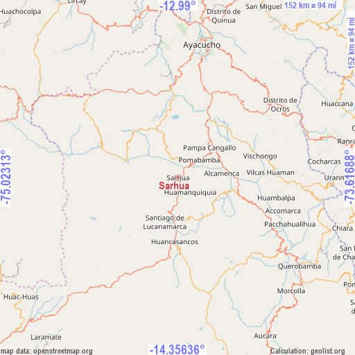
Sarhua GPS coordinates[2]
13° 40' 27.012" South, 74° 19' 12" West
| Map corner | latitude | longitude |
|---|---|---|
| Upper-left | -12.99°, | -75.02313° |
| Center: | -13.67417°, | -74.32° |
| Lower-right: | -14.35636°, | -73.61688° |
| Map W x H: | 151.9×151.9 km | = 94.4×94.4mi |
| max Lat: | -0.96667° ⇑69.7% North |
| Sarhua: | -13.67417° |
| min Lat: | ⇓30.3% South -18.01465° |
| min Long | Sarhua | max Long |
| -81.30472° | -74.32° | -69.04167° |
| W 63.2%⇐ | ⇒36.8% E |
Elevation
Elevation of Sarhua is 3138 m = 10295 ft, and this is 819.3 m = 2688 ft above average elevation for this country.
| Max E: |
5022 m = 16476 ft | 40.6% |
| Sarhua | 3138 m 10295 ft | |
| Avg. | 2318.7 m = 7607 ft | |
Min E: |
1 m = 3 ft | 59.4% |
See also: Peru elevation on elevation.city.
Geographical zone
Sarhua is located in South Torrid zone (between Equator and Tropic of Capricorn). Distance of this Southern Tropic circle is 1085.5 km =674.5 mi to South.| Distance of | km | miles | from Sarhua |
|---|---|---|---|
| Equator | 1520.4 | 944.7 | to North |
| Tropic Capricorn | 1085.5 | 674.5 | to South |
| Antarctic Circle | 5880.7 | 3654.1 | to South |
| South Pole | 8486.6 | 5273.3 | to South |


Nearby cities:
15 places around Sarhua: (largest is in red/bold)
• Cangallo
19.7 km =12.2 mi,  75°
75°
• Carapo
18.3 km =11.4 mi,  177°
177°
• Cayara
38.2 km =23.7 mi,  110°
110°
• Chiara
46.3 km =28.8 mi,  15°
15°
• Chuschi
10.4 km =6.5 mi,  341°
341°
• Colca
31.3 km =19.4 mi,  98°
98°
• Huamanquiquia
8 km =5 mi,  140°
140°
• Huambalpa
42.8 km =26.6 mi, 101°
• Huancapi
28.9 km =18 mi, 108°
• Pampa Cangallo
18.6 km =11.6 mi,  46°
46°
• Pomabamba
12 km =7.5 mi, 49°
• Sacsamarca
30.3 km =18.8 mi, 178°
• Totos
25 km =15.5 mi,  298°
298°
• Vilcanchos
23.9 km =14.9 mi,  286°
286°
• Vischongo
36.4 km =22.6 mi,  74°
74°
Sources, notices
• [Note1] Compared only with cities in Peru existing in our database
• [Src1] Map data: © OpenStreetMap contributors (CC-BY-SA)
• [Src2] Other city data from geonames.org with taken over terms of usage.
• [Src3] Geographical zone / Annual Mean Temperature by Robert A. Rohde @ Wikipedia
