Cangallo geodata
Cangallo (Ayacucho) is a seat of a third-order administrative division; located in Peru in America/Lima (GMT-5) time zone. In our database, there are 305 cities with bigger population. Compared to other cities in Peru, 68.8% of cities are located further ↑North; 64.9% of cities are located further ←West and 57.8% of cities have higher elevation than Cangallo. Note1


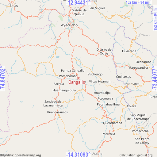
Cangallo GPS coordinates[2]
13° 37' 42.996" South, 74° 8' 38.004" West
| Map corner | latitude | longitude |
|---|---|---|
| Upper-left | -12.94431°, | -74.84702° |
| Center: | -13.62861°, | -74.14389° |
| Lower-right: | -14.31093°, | -73.44077° |
| Map W x H: | 152×152 km | = 94.4×94.4mi |
| max Lat: | -0.96667° ⇑68.8% North |
| Cangallo: | -13.62861° |
| min Lat: | ⇓31.2% South -18.01465° |
| min Long | Cangallo | max Long |
| -81.30472° | -74.14389° | -69.04167° |
| W 64.9%⇐ | ⇒35.1% E |
Elevation
Elevation of Cangallo is 2565 m = 8415 ft, and this is 246.3 m = 808 ft above average elevation for this country.
| Max E: |
5022 m = 16476 ft | 57.8% |
| Cangallo | 2565 m 8415 ft | |
| Avg. | 2318.7 m = 7607 ft | |
Min E: |
1 m = 3 ft | 42.2% |
See also: Peru elevation on elevation.city.
Geographical zone
Cangallo is located in South Torrid zone (between Equator and Tropic of Capricorn). Distance of this Southern Tropic circle is 1090.6 km =677.7 mi to South.| Distance of | km | miles | from Cangallo |
|---|---|---|---|
| Equator | 1515.4 | 941.6 | to North |
| Tropic Capricorn | 1090.6 | 677.7 | to South |
| Antarctic Circle | 5885.8 | 3657.3 | to South |
| South Pole | 8491.7 | 5276.5 | to South |


Nearby cities:
15 places around Cangallo: (largest is in red/bold)
• Accomarca
32.2 km =20 mi,  126°
126°
• Carapo
29.6 km =18.4 mi,  217°
217°
• Cayara
24.9 km =15.5 mi,  137°
137°
• Chiara
40.1 km =24.9 mi,  350°
350°
• Chuschi
22.8 km =14.2 mi,  282°
282°
• Colca
15.3 km =9.5 mi, 128°
• Huamanquiquia
17.9 km =11.1 mi,  231°
231°
• Huambalpa
26.6 km =16.5 mi,  120°
120°
• Huancapi
16.5 km =10.3 mi,  149°
149°
• Ocros
36.2 km =22.5 mi,  43°
43°
• Pampa Cangallo
9.5 km =5.9 mi,  324°
324°
• Pomabamba
10.2 km =6.3 mi,  285°
285°
• Sacsamarca
39.7 km =24.7 mi,  207°
207°
• Sarhua
19.7 km =12.2 mi,  255°
255°
• Vischongo
16.7 km =10.4 mi,  74°
74°
Sources, notices
• [Note1] Compared only with cities in Peru existing in our database
• [Src1] Map data: © OpenStreetMap contributors (CC-BY-SA)
• [Src2] Other city data from geonames.org with taken over terms of usage.
• [Src3] Geographical zone / Annual Mean Temperature by Robert A. Rohde @ Wikipedia
