Carapo geodata
Carapo (Ayacucho) is a seat of a third-order administrative division; located in Peru in America/Lima (GMT-5) time zone. In our database, there are 305 cities with bigger population. Compared to other cities in Peru, 71.7% of cities are located further ↑North; 63.3% of cities are located further ←West and 65.3% of cities have lower elevation than Carapo. Note1


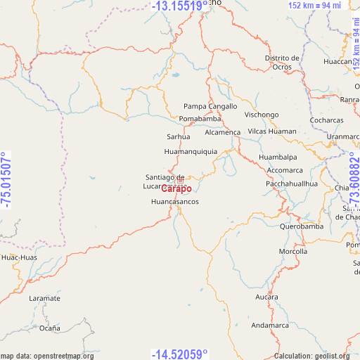
Carapo GPS coordinates[2]
13° 50' 20.004" South, 74° 18' 42.984" West
| Map corner | latitude | longitude |
|---|---|---|
| Upper-left | -13.15519°, | -75.01507° |
| Center: | -13.83889°, | -74.31194° |
| Lower-right: | -14.52059°, | -73.60882° |
| Map W x H: | 151.8×151.8 km | = 94.3×94.3mi |
| max Lat: | -0.96667° ⇑71.7% North |
| Carapo: | -13.83889° |
| min Lat: | ⇓28.3% South -18.01465° |
| min Long | Carapo | max Long |
| -81.30472° | -74.31194° | -69.04167° |
| W 63.3%⇐ | ⇒36.7% E |
Elevation
Elevation of Carapo is 3265 m = 10712 ft, and this is 946.3 m = 3105 ft above average elevation for this country.
| Max E: |
5022 m = 16476 ft | 34.7% |
| Carapo | 3265 m 10712 ft | |
| Avg. | 2318.7 m = 7607 ft | |
Min E: |
1 m = 3 ft | 65.3% |
See also: Peru elevation on elevation.city.
Geographical zone
Carapo is located in South Torrid zone (between Equator and Tropic of Capricorn). Distance of this Southern Tropic circle is 1067.2 km =663.1 mi to South.| Distance of | km | miles | from Carapo |
|---|---|---|---|
| Equator | 1538.7 | 956.1 | to North |
| Tropic Capricorn | 1067.2 | 663.1 | to South |
| Antarctic Circle | 5862.4 | 3642.7 | to South |
| South Pole | 8468.3 | 5262 | to South |


Nearby cities:
15 places around Carapo: (largest is in red/bold)
• Accomarca
44.4 km =27.6 mi,  84°
84°
• Cangallo
29.6 km =18.4 mi,  37°
37°
• Cayara
35.2 km =21.9 mi, 81°
• Chuschi
28.5 km =17.7 mi,  351°
351°
• Colca
33.1 km =20.6 mi,  65°
65°
• Huamanquiquia
12.8 km =8 mi,  19°
19°
• Huambalpa
42.3 km =26.3 mi, 76°
• Huancapi
28 km =17.4 mi, 70°
• Pampa Cangallo
33.6 km =20.9 mi, 22°
• Pomabamba
27.4 km =17 mi, 17°
• Sacsamarca
12 km =7.5 mi,  179°
179°
• Sarhua
18.3 km =11.4 mi,  357°
357°
• Totos
37.9 km =23.5 mi,  322°
322°
• Vilcanchos
34.7 km =21.6 mi, 316°
• Vischongo
44.1 km =27.4 mi,  51°
51°
Sources, notices
• [Note1] Compared only with cities in Peru existing in our database
• [Src1] Map data: © OpenStreetMap contributors (CC-BY-SA)
• [Src2] Other city data from geonames.org with taken over terms of usage.
• [Src3] Geographical zone / Annual Mean Temperature by Robert A. Rohde @ Wikipedia
