Quiaca geodata
Quiaca (Puno) is a seat of a third-order administrative division; located in Peru in America/Lima (GMT-5) time zone. In our database, there are 305 cities with bigger population. Compared to other cities in Peru, 81.9% of cities are located further ↑North; 99.2% of cities are located further ←West and 53.5% of cities have lower elevation than Quiaca. Note1


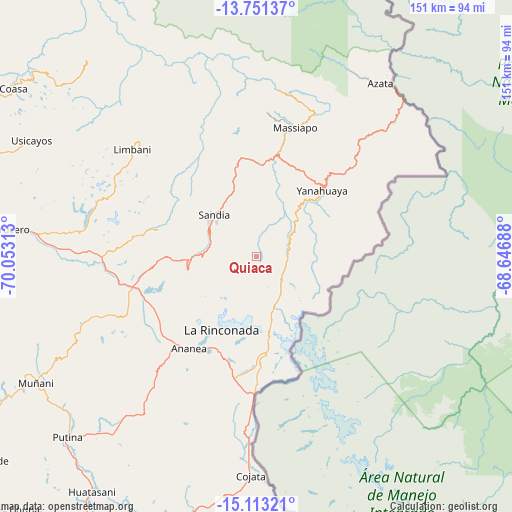
Quiaca GPS coordinates[2]
14° 25' 59.988" South, 69° 21' 0" West
| Map corner | latitude | longitude |
|---|---|---|
| Upper-left | -13.75137°, | -70.05313° |
| Center: | -14.43333°, | -69.35° |
| Lower-right: | -15.11321°, | -68.64688° |
| Map W x H: | 151.4×151.4 km | = 94.1×94.1mi |
| max Lat: | -0.96667° ⇑81.9% North |
| Quiaca: | -14.43333° |
| min Lat: | ⇓18.1% South -18.01465° |
| min Long | Quiaca | max Long |
| -81.30472° | -69.35° | -69.04167° |
| W 99.2%⇐ | ⇒0.8% E |
Elevation
Elevation of Quiaca is 2982 m = 9783 ft, and this is 663.3 m = 2176 ft above average elevation for this country.
| Max E: |
5022 m = 16476 ft | 46.5% |
| Quiaca | 2982 m 9783 ft | |
| Avg. | 2318.7 m = 7607 ft | |
Min E: |
1 m = 3 ft | 53.5% |
See also: Peru elevation on elevation.city.
Geographical zone
Quiaca is located in South Torrid zone (between Equator and Tropic of Capricorn). Distance of this Southern Tropic circle is 1001.1 km =622.1 mi to South.| Distance of | km | miles | from Quiaca |
|---|---|---|---|
| Equator | 1604.8 | 997.2 | to North |
| Tropic Capricorn | 1001.1 | 622.1 | to South |
| Antarctic Circle | 5796.3 | 3601.7 | to South |
| South Pole | 8402.2 | 5220.9 | to South |


Nearby cities:
15 places around Quiaca: (largest is in red/bold)
• Ananea
36.6 km =22.7 mi,  215°
215°
• Cojata
64.9 km =40.3 mi,  181°
181°
• Crucero
70.6 km =43.9 mi,  277°
277°
• Cuyocuyo
20.6 km =12.8 mi,  258°
258°
• Inchupalla
72.5 km =45 mi,  209°
209°
• La Rinconada
24.3 km =15.1 mi, 205°
• Limbani
48.4 km =30.1 mi,  311°
311°
• Muñani
74.4 km =46.2 mi,  240°
240°
• Patambuco
30.1 km =18.7 mi,  285°
285°
• Phara
46 km =28.6 mi, 312°
• Putina
77.3 km =48 mi,  225°
225°
• Sandia
24 km =14.9 mi,  338°
338°
• Sina
10.3 km =6.4 mi,  135°
135°
• Usicayos
74.7 km =46.4 mi,  297°
297°
• Yanahuaya
24.6 km =15.3 mi,  41°
41°
Sources, notices
• [Note1] Compared only with cities in Peru existing in our database
• [Src1] Map data: © OpenStreetMap contributors (CC-BY-SA)
• [Src2] Other city data from geonames.org with taken over terms of usage.
• [Src3] Geographical zone / Annual Mean Temperature by Robert A. Rohde @ Wikipedia
