Patambuco geodata
Patambuco (Puno) is a seat of a third-order administrative division; located in Peru in America/Lima (GMT-5) time zone. In our database, there are 305 cities with bigger population. Compared to other cities in Peru, 81% of cities are located further ↑North; 98.1% of cities are located further ←West and 83.3% of cities have lower elevation than Patambuco. Note1


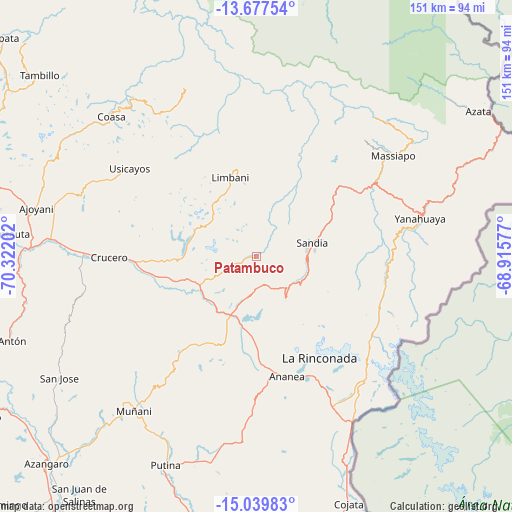
Patambuco GPS coordinates[2]
14° 21' 34.992" South, 69° 37' 8.004" West
| Map corner | latitude | longitude |
|---|---|---|
| Upper-left | -13.67754°, | -70.32202° |
| Center: | -14.35972°, | -69.61889° |
| Lower-right: | -15.03983°, | -68.91577° |
| Map W x H: | 151.5×151.5 km | = 94.1×94.1mi |
| max Lat: | -0.96667° ⇑81% North |
| Patambuco: | -14.35972° |
| min Lat: | ⇓19% South -18.01465° |
| min Long | Patambuco | max Long |
| -81.30472° | -69.61889° | -69.04167° |
| W 98.1%⇐ | ⇒1.9% E |
Elevation
Elevation of Patambuco is 3594 m = 11791 ft, and this is 1275.3 m = 4184 ft above average elevation for this country.
| Max E: |
5022 m = 16476 ft | 16.7% |
| Patambuco | 3594 m 11791 ft | |
| Avg. | 2318.7 m = 7607 ft | |
Min E: |
1 m = 3 ft | 83.3% |
See also: Peru elevation on elevation.city.
Geographical zone
Patambuco is located in South Torrid zone (between Equator and Tropic of Capricorn). Distance of this Southern Tropic circle is 1009.3 km =627.1 mi to South.| Distance of | km | miles | from Patambuco |
|---|---|---|---|
| Equator | 1596.7 | 992.1 | to North |
| Tropic Capricorn | 1009.3 | 627.1 | to South |
| Antarctic Circle | 5804.5 | 3606.7 | to South |
| South Pole | 8410.4 | 5226 | to South |


Nearby cities:
15 places around Patambuco: (largest is in red/bold)
• Ananea
38.6 km =24 mi,  168°
168°
• Coasa
54.8 km =34.1 mi,  316°
316°
• Crucero
41.1 km =25.5 mi,  271°
271°
• Cuyocuyo
15.2 km =9.4 mi,  144°
144°
• La Rinconada
35.4 km =22 mi,  148°
148°
• Limbani
24.7 km =15.3 mi,  342°
342°
• Muñani
57.6 km =35.8 mi,  218°
218°
• Phara
23.6 km =14.7 mi,  348°
348°
• Potoni
50.1 km =31.1 mi, 266°
• Putina
67.4 km =41.9 mi,  203°
203°
• Quiaca
30.1 km =18.7 mi,  105°
105°
• Sandia
24.4 km =15.2 mi,  54°
54°
• Sina
39.4 km =24.5 mi, 113°
• Usicayos
45.6 km =28.3 mi,  304°
304°
• Yanahuaya
46.3 km =28.8 mi,  77°
77°
Sources, notices
• [Note1] Compared only with cities in Peru existing in our database
• [Src1] Map data: © OpenStreetMap contributors (CC-BY-SA)
• [Src2] Other city data from geonames.org with taken over terms of usage.
• [Src3] Geographical zone / Annual Mean Temperature by Robert A. Rohde @ Wikipedia
