Putina geodata
Putina (Puno) is a populated place; located in Peru in America/Lima (GMT-5) time zone. With population of 8,118 people, there are 167 cities with bigger population in this country. Compared to other cities in Peru, 89.2% of cities are located further ↑North; 99% of cities are located further ←West and 88.9% of cities have lower elevation than Putina. Note1


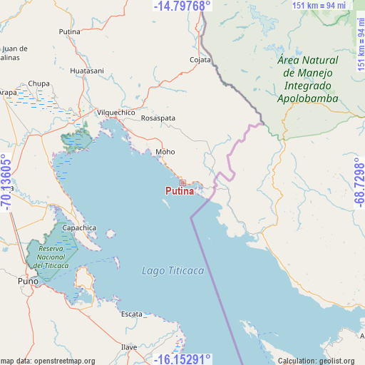
Putina GPS coordinates[2]
15° 28' 35.04" South, 69° 25' 58.512" West
| Map corner | latitude | longitude |
|---|---|---|
| Upper-left | -14.79768°, | -70.13605° |
| Center: | -15.4764°, | -69.43292° |
| Lower-right: | -16.15291°, | -68.7298° |
| Map W x H: | 150.7×150.7 km | = 93.6×93.6mi |
| max Lat: | -0.96667° ⇑89.2% North |
| Putina: | -15.4764° |
| min Lat: | ⇓10.8% South -18.01465° |
| min Long | Putina | max Long |
| -81.30472° | -69.43292° | -69.04167° |
| W 99%⇐ | ⇒1% E |
Elevation
Elevation of Putina is 3821 m = 12536 ft, and this is 1502.3 m = 4929 ft above average elevation for this country.
| Max E: |
5022 m = 16476 ft | 11.1% |
| Putina | 3821 m 12536 ft | |
| Avg. | 2318.7 m = 7607 ft | |
Min E: |
1 m = 3 ft | 88.9% |
See also: Peru elevation on elevation.city.
Geographical zone
Putina is located in South Torrid zone (between Equator and Tropic of Capricorn). Distance of this Southern Tropic circle is 885.1 km =550 mi to South.| Distance of | km | miles | from Putina |
|---|---|---|---|
| Equator | 1720.8 | 1069.3 | to North |
| Tropic Capricorn | 885.1 | 550 | to South |
| Antarctic Circle | 5680.4 | 3529.6 | to South |
| South Pole | 8286.2 | 5148.8 | to South |


Nearby cities:
15 places around Putina: (largest is in red/bold)
• Ayrampuni
67.7 km =42.1 mi,  314°
314°
• Caminaca
70.2 km =43.6 mi,  284°
284°
• Capachica
44.7 km =27.8 mi,  246°
246°
• Coata
56.3 km =35 mi,  259°
259°
• Cojata
51.6 km =32.1 mi,  7°
7°
• Conima
4.8 km =3 mi,  359°
359°
• Huata
59.3 km =36.8 mi, 254°
• Huayrapata
22.3 km =13.9 mi,  28°
28°
• Inchupalla
59.4 km =36.9 mi,  333°
333°
• Moho
15.8 km =9.8 mi, 332°
• Pusi
53.8 km =33.4 mi, 275°
• Rosaspata
30.8 km =19.1 mi,  339°
339°
• Taquile
42 km =26.1 mi,  219°
219°
• Taraco
60.5 km =37.6 mi,  288°
288°
• Vilque Chico
39.4 km =24.5 mi,  317°
317°
Sources, notices
• [Note1] Compared only with cities in Peru existing in our database
• [Src1] Map data: © OpenStreetMap contributors (CC-BY-SA)
• [Src2] Other city data from geonames.org with taken over terms of usage.
• [Src3] Geographical zone / Annual Mean Temperature by Robert A. Rohde @ Wikipedia
