Moho geodata
Moho (Puno) is a seat of a third-order administrative division; located in Peru in America/Lima (GMT-5) time zone. In our database, there are 305 cities with bigger population. Compared to other cities in Peru, 88.6% of cities are located further ↑North; 98.6% of cities are located further ←West and 95.2% of cities have lower elevation than Moho. Note1


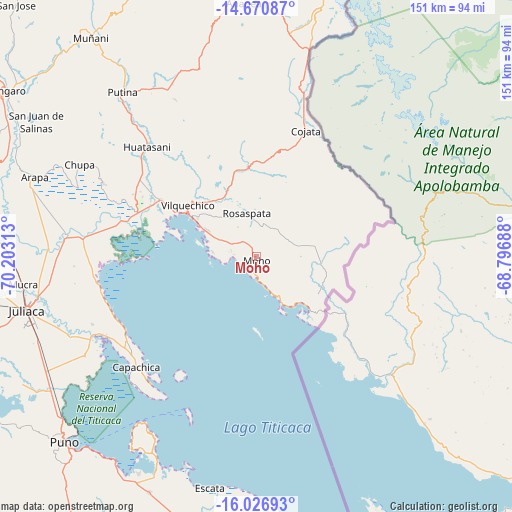
Moho GPS coordinates[2]
15° 21' 0" South, 69° 30' 0" West
| Map corner | latitude | longitude |
|---|---|---|
| Upper-left | -14.67087°, | -70.20313° |
| Center: | -15.35°, | -69.5° |
| Lower-right: | -16.02693°, | -68.79688° |
| Map W x H: | 150.8×150.8 km | = 93.7×93.7mi |
| max Lat: | -0.96667° ⇑88.6% North |
| Moho: | -15.35° |
| min Lat: | ⇓11.4% South -18.01465° |
| min Long | Moho | max Long |
| -81.30472° | -69.5° | -69.04167° |
| W 98.6%⇐ | ⇒1.4% E |
Elevation
Elevation of Moho is 4041 m = 13258 ft, and this is 1722.3 m = 5651 ft above average elevation for this country.
| Max E: |
5022 m = 16476 ft | 4.8% |
| Moho | 4041 m 13258 ft | |
| Avg. | 2318.7 m = 7607 ft | |
Min E: |
1 m = 3 ft | 95.2% |
See also: Peru elevation on elevation.city.
Geographical zone
Moho is located in South Torrid zone (between Equator and Tropic of Capricorn). Distance of this Southern Tropic circle is 899.2 km =558.7 mi to South.| Distance of | km | miles | from Moho |
|---|---|---|---|
| Equator | 1706.8 | 1060.6 | to North |
| Tropic Capricorn | 899.2 | 558.7 | to South |
| Antarctic Circle | 5694.4 | 3538.3 | to South |
| South Pole | 8300.3 | 5157.6 | to South |


Nearby cities:
15 places around Moho: (largest is in red/bold)
• Ayrampuni
53 km =32.9 mi,  309°
309°
• Capachica
46.3 km =28.8 mi,  227°
227°
• Chupa
58.8 km =36.5 mi,  298°
298°
• Coata
53.9 km =33.5 mi,  243°
243°
• Cojata
39.7 km =24.7 mi,  21°
21°
• Conima
11.7 km =7.3 mi,  142°
142°
• Huata
58.1 km =36.1 mi, 239°
• Huayrapata
18.7 km =11.6 mi,  72°
72°
• Inchupalla
43.6 km =27.1 mi,  333°
333°
• Pusi
47.4 km =29.5 mi,  258°
258°
• Putina
15.8 km =9.8 mi,  152°
152°
• Rosaspata
15.2 km =9.4 mi,  346°
346°
• Taquile
50.3 km =31.3 mi,  202°
202°
• Taraco
50.4 km =31.3 mi,  276°
276°
• Vilque Chico
24.6 km =15.3 mi, 307°
Sources, notices
• [Note1] Compared only with cities in Peru existing in our database
• [Src1] Map data: © OpenStreetMap contributors (CC-BY-SA)
• [Src2] Other city data from geonames.org with taken over terms of usage.
• [Src3] Geographical zone / Annual Mean Temperature by Robert A. Rohde @ Wikipedia
