Conima geodata
Conima (Puno) is a seat of a third-order administrative division; located in Peru in America/Lima (GMT-5) time zone. In our database, there are 305 cities with bigger population. Compared to other cities in Peru, 89% of cities are located further ↑North; 98.8% of cities are located further ←West and 96.5% of cities have lower elevation than Conima. Note1


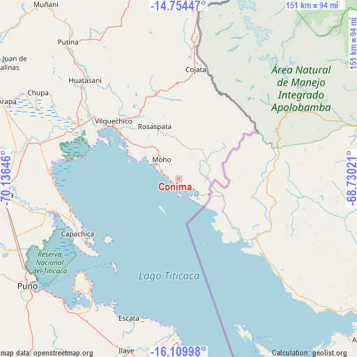
Conima GPS coordinates[2]
15° 25' 59.988" South, 69° 25' 59.988" West
| Map corner | latitude | longitude |
|---|---|---|
| Upper-left | -14.75447°, | -70.13646° |
| Center: | -15.43333°, | -69.43333° |
| Lower-right: | -16.10998°, | -68.73021° |
| Map W x H: | 150.7×150.7 km | = 93.6×93.6mi |
| max Lat: | -0.96667° ⇑89% North |
| Conima: | -15.43333° |
| min Lat: | ⇓11% South -18.01465° |
| min Long | Conima | max Long |
| -81.30472° | -69.43333° | -69.04167° |
| W 98.8%⇐ | ⇒1.2% E |
Elevation
Elevation of Conima is 4151 m = 13619 ft, and this is 1832.3 m = 6011 ft above average elevation for this country.
| Max E: |
5022 m = 16476 ft | 3.5% |
| Conima | 4151 m 13619 ft | |
| Avg. | 2318.7 m = 7607 ft | |
Min E: |
1 m = 3 ft | 96.5% |
See also: Peru elevation on elevation.city.
Geographical zone
Conima is located in South Torrid zone (between Equator and Tropic of Capricorn). Distance of this Southern Tropic circle is 889.9 km =553 mi to South.| Distance of | km | miles | from Conima |
|---|---|---|---|
| Equator | 1716 | 1066.3 | to North |
| Tropic Capricorn | 889.9 | 553 | to South |
| Antarctic Circle | 5685.1 | 3532.6 | to South |
| South Pole | 8291 | 5151.8 | to South |


Nearby cities:
15 places around Conima: (largest is in red/bold)
• Ayrampuni
64.4 km =40 mi,  311°
311°
• Caminaca
69.1 km =42.9 mi,  280°
280°
• Capachica
46.7 km =29 mi,  241°
241°
• Coata
57.3 km =35.6 mi,  255°
255°
• Cojata
46.9 km =29.1 mi,  8°
8°
• Huata
60.7 km =37.7 mi,  250°
250°
• Huayrapata
18.3 km =11.4 mi,  35°
35°
• Inchupalla
55.1 km =34.2 mi,  330°
330°
• Moho
11.7 km =7.3 mi,  322°
322°
• Pusi
53.6 km =33.3 mi,  270°
270°
• Putina
4.8 km =3 mi,  179°
179°
• Rosaspata
26.4 km =16.4 mi,  336°
336°
• Taquile
45.7 km =28.4 mi,  215°
215°
• Taraco
59.1 km =36.7 mi, 284°
• Vilque Chico
36 km =22.4 mi, 311°
Sources, notices
• [Note1] Compared only with cities in Peru existing in our database
• [Src1] Map data: © OpenStreetMap contributors (CC-BY-SA)
• [Src2] Other city data from geonames.org with taken over terms of usage.
• [Src3] Geographical zone / Annual Mean Temperature by Robert A. Rohde @ Wikipedia
