Taquile geodata
Taquile (Puno) is a populated place; located in Peru in America/Lima (GMT-5) time zone. With population of 2,000 people, there are 295 cities with bigger population in this country. Compared to other cities in Peru, 92.3% of cities are located further ↑North; 97.7% of cities are located further ←West and 92.1% of cities have lower elevation than Taquile. Note1


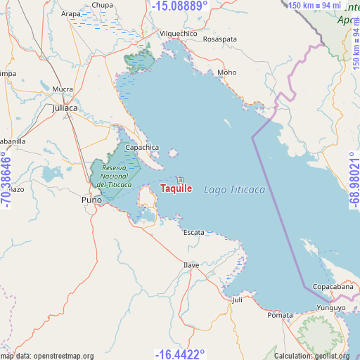
Taquile GPS coordinates[2]
15° 46' 0.012" South, 69° 40' 59.988" West
| Map corner | latitude | longitude |
|---|---|---|
| Upper-left | -15.08889°, | -70.38646° |
| Center: | -15.76667°, | -69.68333° |
| Lower-right: | -16.4422°, | -68.98021° |
| Map W x H: | 150.5×150.5 km | = 93.5×93.5mi |
| max Lat: | -0.96667° ⇑92.3% North |
| Taquile: | -15.76667° |
| min Lat: | ⇓7.7% South -18.01465° |
| min Long | Taquile | max Long |
| -81.30472° | -69.68333° | -69.04167° |
| W 97.7%⇐ | ⇒2.3% E |
Elevation
Elevation of Taquile is 3911 m = 12831 ft, and this is 1592.3 m = 5224 ft above average elevation for this country.
| Max E: |
5022 m = 16476 ft | 7.9% |
| Taquile | 3911 m 12831 ft | |
| Avg. | 2318.7 m = 7607 ft | |
Min E: |
1 m = 3 ft | 92.1% |
See also: Peru elevation on elevation.city.
Geographical zone
Taquile is located in South Torrid zone (between Equator and Tropic of Capricorn). Distance of this Southern Tropic circle is 852.8 km =529.9 mi to South.| Distance of | km | miles | from Taquile |
|---|---|---|---|
| Equator | 1753.1 | 1089.3 | to North |
| Tropic Capricorn | 852.8 | 529.9 | to South |
| Antarctic Circle | 5648.1 | 3509.6 | to South |
| South Pole | 8254 | 5128.8 | to South |


Nearby cities:
15 places around Taquile: (largest is in red/bold)
• Atuncolla
50.8 km =31.6 mi,  280°
280°
• Capachica
20.6 km =12.8 mi,  316°
316°
• Caracoto
49.8 km =30.9 mi,  296°
296°
• Coata
36.2 km =22.5 mi,  307°
307°
• Conima
45.7 km =28.4 mi,  35°
35°
• Huata
34.6 km =21.5 mi, 298°
• Ilave
35.3 km =21.9 mi,  177°
177°
• Juli
55.9 km =34.7 mi,  153°
153°
• Moho
50.3 km =31.3 mi,  22°
22°
• Paucarcolla
39.4 km =24.5 mi, 275°
• Pilcuyo
39.1 km =24.3 mi,  161°
161°
• Puno
37 km =23 mi,  256°
256°
• Pusi
45.7 km =28.4 mi, 324°
• Putina
42 km =26.1 mi, 39°
• Tiquillaca
55.6 km =34.5 mi, 264°
Sources, notices
• [Note1] Compared only with cities in Peru existing in our database
• [Src1] Map data: © OpenStreetMap contributors (CC-BY-SA)
• [Src2] Other city data from geonames.org with taken over terms of usage.
• [Src3] Geographical zone / Annual Mean Temperature by Robert A. Rohde @ Wikipedia
