Ilave geodata
Ilave (Puno) is a seat of a third-order administrative division; located in Peru in America/Lima (GMT-5) time zone. With population of 16,033 people, there are 99 cities with bigger population in this country. Compared to other cities in Peru, 93.8% of cities are located further ↑North; 97.9% of cities are located further ←West and 89.8% of cities have lower elevation than Ilave. Note1


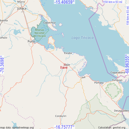
Ilave GPS coordinates[2]
16° 4' 59.988" South, 69° 40' 0.012" West
| Map corner | latitude | longitude |
|---|---|---|
| Upper-left | -15.40659°, | -70.3698° |
| Center: | -16.08333°, | -69.66667° |
| Lower-right: | -16.75777°, | -68.96355° |
| Map W x H: | 150.2×150.2 km | = 93.3×93.3mi |
| max Lat: | -0.96667° ⇑93.8% North |
| Ilave: | -16.08333° |
| min Lat: | ⇓6.2% South -18.01465° |
| min Long | Ilave | max Long |
| -81.30472° | -69.66667° | -69.04167° |
| W 97.9%⇐ | ⇒2.1% E |
Elevation
Elevation of Ilave is 3841 m = 12602 ft, and this is 1522.3 m = 4994 ft above average elevation for this country.
| Max E: |
5022 m = 16476 ft | 10.2% |
| Ilave | 3841 m 12602 ft | |
| Avg. | 2318.7 m = 7607 ft | |
Min E: |
1 m = 3 ft | 89.8% |
See also: Peru elevation on elevation.city.
Geographical zone
Ilave is located in South Torrid zone (between Equator and Tropic of Capricorn). Distance of this Southern Tropic circle is 817.6 km =508 mi to South.| Distance of | km | miles | from Ilave |
|---|---|---|---|
| Equator | 1788.3 | 1111.2 | to North |
| Tropic Capricorn | 817.6 | 508 | to South |
| Antarctic Circle | 5612.9 | 3487.7 | to South |
| South Pole | 8218.8 | 5106.9 | to South |


Nearby cities:
15 places around Ilave: (largest is in red/bold)
• Atuncolla
68.2 km =42.4 mi,  310°
310°
• Capachica
52.5 km =32.6 mi,  342°
342°
• Coata
65 km =40.4 mi,  332°
332°
• Huata
61 km =37.9 mi, 328°
• Juli
27.5 km =17.1 mi,  122°
122°
• Laraqueri
41.3 km =25.7 mi,  262°
262°
• Paucarcolla
56.5 km =35.1 mi, 313°
• Pilcuyo
10.8 km =6.7 mi,  99°
99°
• Pomata
44.1 km =27.4 mi, 117°
• Puno
46.3 km =28.8 mi, 305°
• Putina
72 km =44.7 mi,  20°
20°
• Taquile
35.3 km =21.9 mi,  357°
357°
• Tiquillaca
64.3 km =40 mi,  297°
297°
• Vilque
71.6 km =44.5 mi, 299°
• Yunguyo
65 km =40.4 mi,  106°
106°
Sources, notices
• [Note1] Compared only with cities in Peru existing in our database
• [Src1] Map data: © OpenStreetMap contributors (CC-BY-SA)
• [Src2] Other city data from geonames.org with taken over terms of usage.
• [Src3] Geographical zone / Annual Mean Temperature by Robert A. Rohde @ Wikipedia
