Ocobamba geodata
Ocobamba (Apurímac) is a seat of a third-order administrative division; located in Peru in America/Lima (GMT-5) time zone. In our database, there are 305 cities with bigger population. Compared to other cities in Peru, 66.3% of cities are located further ↑North; 69.7% of cities are located further ←West and 54.2% of cities have lower elevation than Ocobamba. Note1


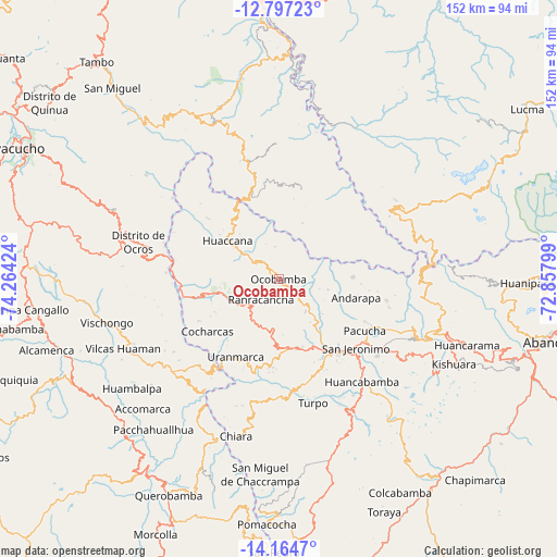
Ocobamba GPS coordinates[2]
13° 28' 54.984" South, 73° 33' 39.996" West
| Map corner | latitude | longitude |
|---|---|---|
| Upper-left | -12.79723°, | -74.26424° |
| Center: | -13.48194°, | -73.56111° |
| Lower-right: | -14.1647°, | -72.85799° |
| Map W x H: | 152×152.1 km | = 94.4×94.5mi |
| max Lat: | -0.96667° ⇑66.3% North |
| Ocobamba: | -13.48194° |
| min Lat: | ⇓33.7% South -18.01465° |
| min Long | Ocobamba | max Long |
| -81.30472° | -73.56111° | -69.04167° |
| W 69.7%⇐ | ⇒30.3% E |
Elevation
Elevation of Ocobamba is 3005 m = 9859 ft, and this is 686.3 m = 2252 ft above average elevation for this country.
| Max E: |
5022 m = 16476 ft | 45.8% |
| Ocobamba | 3005 m 9859 ft | |
| Avg. | 2318.7 m = 7607 ft | |
Min E: |
1 m = 3 ft | 54.2% |
See also: Peru elevation on elevation.city.
Geographical zone
Ocobamba is located in South Torrid zone (between Equator and Tropic of Capricorn). Distance of this Southern Tropic circle is 1106.9 km =687.8 mi to South.| Distance of | km | miles | from Ocobamba |
|---|---|---|---|
| Equator | 1499.1 | 931.5 | to North |
| Tropic Capricorn | 1106.9 | 687.8 | to South |
| Antarctic Circle | 5902.1 | 3667.4 | to South |
| South Pole | 8508 | 5286.6 | to South |


Nearby cities:
15 places around Ocobamba: (largest is in red/bold)
• Andahuaylas
26.9 km =16.7 mi,  135°
135°
• Andarapa
21.6 km =13.4 mi,  103°
103°
• Chincheros
17.9 km =11.1 mi,  256°
256°
• Chungui
29.9 km =18.6 mi,  347°
347°
• Cocharcas
24 km =14.9 mi,  233°
233°
• Huaccana
17.4 km =10.8 mi,  307°
307°
• Huancaray
31 km =19.3 mi,  173°
173°
• Ongoy
14.6 km =9.1 mi, 306°
• Pacucha
27.4 km =17 mi,  120°
120°
• Ranracancha
7.5 km =4.7 mi,  219°
219°
• San Jerónimo
28.4 km =17.6 mi,  131°
131°
• Saurama
31.8 km =19.8 mi, 222°
• Talavera
23.8 km =14.8 mi, 143°
• Turpo
35 km =21.7 mi,  164°
164°
• Uripa
13.8 km =8.6 mi,  245°
245°
Sources, notices
• [Note1] Compared only with cities in Peru existing in our database
• [Src1] Map data: © OpenStreetMap contributors (CC-BY-SA)
• [Src2] Other city data from geonames.org with taken over terms of usage.
• [Src3] Geographical zone / Annual Mean Temperature by Robert A. Rohde @ Wikipedia
