Talavera geodata
Talavera (Apurímac) is a seat of a third-order administrative division; located in Peru in America/Lima (GMT-5) time zone. With population of 7,381 people, there are 181 cities with bigger population in this country. Compared to other cities in Peru, 69.3% of cities are located further ↑North; 70.4% of cities are located further ←West and 50.5% of cities have higher elevation than Talavera. Note1


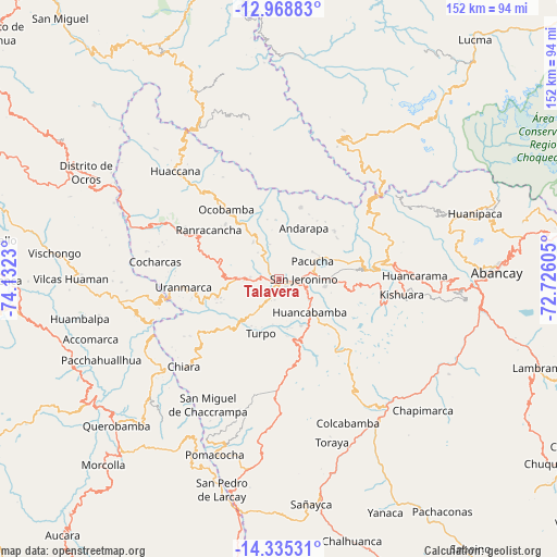
Talavera GPS coordinates[2]
13° 39' 11.016" South, 73° 25' 45.012" West
| Map corner | latitude | longitude |
|---|---|---|
| Upper-left | -12.96883°, | -74.1323° |
| Center: | -13.65306°, | -73.42917° |
| Lower-right: | -14.33531°, | -72.72605° |
| Map W x H: | 151.9×151.9 km | = 94.4×94.4mi |
| max Lat: | -0.96667° ⇑69.3% North |
| Talavera: | -13.65306° |
| min Lat: | ⇓30.7% South -18.01465° |
| min Long | Talavera | max Long |
| -81.30472° | -73.42917° | -69.04167° |
| W 70.4%⇐ | ⇒29.6% E |
Elevation
Elevation of Talavera is 2826 m = 9272 ft, and this is 507.3 m = 1664 ft above average elevation for this country.
| Max E: |
5022 m = 16476 ft | 50.5% |
| Talavera | 2826 m 9272 ft | |
| Avg. | 2318.7 m = 7607 ft | |
Min E: |
1 m = 3 ft | 49.5% |
See also: Peru elevation on elevation.city.
Geographical zone
Talavera is located in South Torrid zone (between Equator and Tropic of Capricorn). Distance of this Southern Tropic circle is 1087.8 km =675.9 mi to South.| Distance of | km | miles | from Talavera |
|---|---|---|---|
| Equator | 1518.1 | 943.3 | to North |
| Tropic Capricorn | 1087.8 | 675.9 | to South |
| Antarctic Circle | 5883.1 | 3655.6 | to South |
| South Pole | 8489 | 5274.8 | to South |


Nearby cities:
15 places around Talavera: (largest is in red/bold)
• Andahuaylas
4.5 km =2.8 mi,  93°
93°
• Andarapa
15.7 km =9.8 mi,  25°
25°
• Chiara
35.1 km =21.8 mi,  227°
227°
• Chincheros
35 km =21.7 mi,  295°
295°
• Cocharcas
33.9 km =21.1 mi,  278°
278°
• Huancarama
37 km =23 mi, 88°
• Huancaray
15.8 km =9.8 mi,  222°
222°
• Kishuara
34.1 km =21.2 mi,  97°
97°
• Ocobamba
23.8 km =14.8 mi,  323°
323°
• Pacucha
10.5 km =6.5 mi,  62°
62°
• Ranracancha
23.2 km =14.4 mi, 304°
• San Jerónimo
7.1 km =4.4 mi, 88°
• Saurama
35.9 km =22.3 mi,  262°
262°
• Turpo
15.5 km =9.6 mi,  198°
198°
• Uripa
30 km =18.6 mi, 296°
Sources, notices
• [Note1] Compared only with cities in Peru existing in our database
• [Src1] Map data: © OpenStreetMap contributors (CC-BY-SA)
• [Src2] Other city data from geonames.org with taken over terms of usage.
• [Src3] Geographical zone / Annual Mean Temperature by Robert A. Rohde @ Wikipedia
