Andahuaylas geodata
Andahuaylas (Apurímac) is a seat of a third-order administrative division; located in Peru in America/Lima (GMT-5) time zone. With population of 17,444 people, there are 91 cities with bigger population in this country. Compared to other cities in Peru, 69.4% of cities are located further ↑North; 70.5% of cities are located further ←West and 51.4% of cities have lower elevation than Andahuaylas. Note1
Administrative division(s):
- Level 1: Apurímac
- Level 2: Provincia de Andahuaylas
- Level 3: Andahuaylas


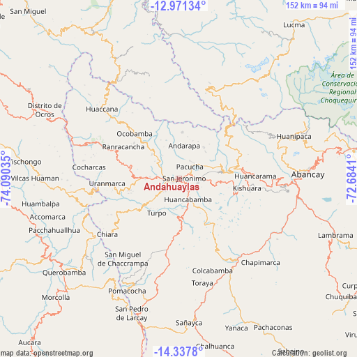
Andahuaylas GPS coordinates[2]
13° 39' 20.016" South, 73° 23' 13.992" West
| Map corner | latitude | longitude |
|---|---|---|
| Upper-left | -12.97134°, | -74.09035° |
| Center: | -13.65556°, | -73.38722° |
| Lower-right: | -14.3378°, | -72.6841° |
| Map W x H: | 151.9×151.9 km | = 94.4×94.4mi |
| max Lat: | -0.96667° ⇑69.4% North |
| Andahuaylas: | -13.65556° |
| min Lat: | ⇓30.6% South -18.01465° |
| min Long | Andahuaylas | max Long |
| -81.30472° | -73.38722° | -69.04167° |
| W 70.5%⇐ | ⇒29.5% E |
Elevation
Elevation of Andahuaylas is 2902 m = 9521 ft, and this is 583.3 m = 1914 ft above average elevation for this country.
| Max E: |
5022 m = 16476 ft | 48.6% |
| Andahuaylas | 2902 m 9521 ft | |
| Avg. | 2318.7 m = 7607 ft | |
Min E: |
1 m = 3 ft | 51.4% |
See also: Peru elevation on elevation.city.
Geographical zone
Andahuaylas is located in South Torrid zone (between Equator and Tropic of Capricorn). Distance of this Southern Tropic circle is 1087.6 km =675.8 mi to South.| Distance of | km | miles | from Andahuaylas |
|---|---|---|---|
| Equator | 1518.4 | 943.5 | to North |
| Tropic Capricorn | 1087.6 | 675.8 | to South |
| Antarctic Circle | 5882.8 | 3655.4 | to South |
| South Pole | 8488.7 | 5274.6 | to South |


Nearby cities:
15 places around Andahuaylas: (largest is in red/bold)
• Andarapa
14.6 km =9.1 mi,  9°
9°
• Chiara
38.4 km =23.9 mi,  231°
231°
• Cocharcas
38.5 km =23.9 mi,  277°
277°
• Huancarama
32.5 km =20.2 mi,  87°
87°
• Huancaray
19 km =11.8 mi, 232°
• Kishuara
29.6 km =18.4 mi,  98°
98°
• Lucre
37 km =23 mi,  151°
151°
• Ocobamba
26.9 km =16.7 mi,  315°
315°
• Pacobamba
32.8 km =20.4 mi,  82°
82°
• Pacucha
7 km =4.3 mi,  42°
42°
• Ranracancha
27.2 km =16.9 mi,  299°
299°
• San Jerónimo
2.6 km =1.6 mi, 79°
• Talavera
4.5 km =2.8 mi,  273°
273°
• Turpo
17.2 km =10.7 mi,  212°
212°
• Uripa
34.2 km =21.3 mi,  293°
293°
Sources, notices
• [Note1] Compared only with cities in Peru existing in our database
• [Src1] Map data: © OpenStreetMap contributors (CC-BY-SA)
• [Src2] Other city data from geonames.org with taken over terms of usage.
• [Src3] Geographical zone / Annual Mean Temperature by Robert A. Rohde @ Wikipedia
