Andarapa geodata
Andarapa (Apurímac) is a seat of a third-order administrative division; located in Peru in America/Lima (GMT-5) time zone. In our database, there are 305 cities with bigger population. Compared to other cities in Peru, 67% of cities are located further ↑North; 70.7% of cities are located further ←West and 51.6% of cities have lower elevation than Andarapa. Note1


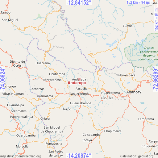
Andarapa GPS coordinates[2]
13° 31' 33.996" South, 73° 21' 57.996" West
| Map corner | latitude | longitude |
|---|---|---|
| Upper-left | -12.84152°, | -74.06924° |
| Center: | -13.52611°, | -73.36611° |
| Lower-right: | -14.20874°, | -72.66299° |
| Map W x H: | 152×152 km | = 94.4×94.4mi |
| max Lat: | -0.96667° ⇑67% North |
| Andarapa: | -13.52611° |
| min Lat: | ⇓33% South -18.01465° |
| min Long | Andarapa | max Long |
| -81.30472° | -73.36611° | -69.04167° |
| W 70.7%⇐ | ⇒29.3% E |
Elevation
Elevation of Andarapa is 2914 m = 9560 ft, and this is 595.3 m = 1953 ft above average elevation for this country.
| Max E: |
5022 m = 16476 ft | 48.4% |
| Andarapa | 2914 m 9560 ft | |
| Avg. | 2318.7 m = 7607 ft | |
Min E: |
1 m = 3 ft | 51.6% |
See also: Peru elevation on elevation.city.
Geographical zone
Andarapa is located in South Torrid zone (between Equator and Tropic of Capricorn). Distance of this Southern Tropic circle is 1102 km =684.8 mi to South.| Distance of | km | miles | from Andarapa |
|---|---|---|---|
| Equator | 1504 | 934.5 | to North |
| Tropic Capricorn | 1102 | 684.8 | to South |
| Antarctic Circle | 5897.2 | 3664.3 | to South |
| South Pole | 8503.1 | 5283.6 | to South |


Nearby cities:
15 places around Andarapa: (largest is in red/bold)
• Andahuaylas
14.6 km =9.1 mi,  189°
189°
• Chincheros
38.5 km =23.9 mi,  271°
271°
• Huaccana
38.2 km =23.7 mi,  293°
293°
• Huancarama
33 km =20.5 mi,  113°
113°
• Huancaray
31.2 km =19.4 mi,  214°
214°
• Kishuara
32.8 km =20.4 mi,  124°
124°
• Ocobamba
21.6 km =13.4 mi,  283°
283°
• Ongoy
35.5 km =22.1 mi, 292°
• Pacobamba
31.9 km =19.8 mi, 108°
• Pacucha
9.5 km =5.9 mi,  165°
165°
• Ranracancha
25.9 km =16.1 mi, 268°
• San Jerónimo
13.9 km =8.6 mi,  179°
179°
• Talavera
15.7 km =9.8 mi, 205°
• Turpo
31.1 km =19.3 mi,  201°
201°
• Uripa
33.6 km =20.9 mi, 268°
Sources, notices
• [Note1] Compared only with cities in Peru existing in our database
• [Src1] Map data: © OpenStreetMap contributors (CC-BY-SA)
• [Src2] Other city data from geonames.org with taken over terms of usage.
• [Src3] Geographical zone / Annual Mean Temperature by Robert A. Rohde @ Wikipedia
