Nazca geodata
Nazca (Ica) is a seat of a third-order administrative division; located in Peru in America/Lima (GMT-5) time zone. With population of 23,556 people, there are 75 cities with bigger population in this country. Compared to other cities in Peru, 84.5% of cities are located further ↑North; 59.3% of cities are located further ←West and 76.9% of cities have higher elevation than Nazca. Note1


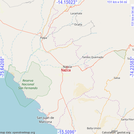
Nazca GPS coordinates[2]
14° 49' 51.528" South, 74° 56' 20.22" West
| Map corner | latitude | longitude |
|---|---|---|
| Upper-left | -14.15023°, | -75.64208° |
| Center: | -14.83098°, | -74.93895° |
| Lower-right: | -15.5096°, | -74.23583° |
| Map W x H: | 151.1×151.2 km | = 93.9×94mi |
| max Lat: | -0.96667° ⇑84.5% North |
| Nazca: | -14.83098° |
| min Lat: | ⇓15.5% South -18.01465° |
| min Long | Nazca | max Long |
| -81.30472° | -74.93895° | -69.04167° |
| W 59.3%⇐ | ⇒40.7% E |
Elevation
Elevation of Nazca is 584 m = 1916 ft, and this is 1734.7 m = 5691 ft below average elevation for this country.
| Max E: |
5022 m = 16476 ft | 76.9% |
| Avg. | 2318.7 m = 7607 ft | |
| Nazca | 584 m = 1916 ft | |
Min E: |
1 m = 3 ft | 23.1% |
See also: Peru elevation on elevation.city.
Geographical zone
Nazca is located in South Torrid zone (between Equator and Tropic of Capricorn). Distance of this Southern Tropic circle is 956.9 km =594.6 mi to South.| Distance of | km | miles | from Nazca |
|---|---|---|---|
| Equator | 1649.1 | 1024.7 | to North |
| Tropic Capricorn | 956.9 | 594.6 | to South |
| Antarctic Circle | 5752.1 | 3574.2 | to South |
| South Pole | 8358 | 5193.4 | to South |


Nearby cities:
15 places around Nazca: (largest is in red/bold)
• Acarí
74.6 km =46.4 mi,  152°
152°
• Changuillo
35.8 km =22.2 mi,  301°
301°
• El Ingenio
24.3 km =15.1 mi,  328°
328°
• Laramate
65.1 km =40.5 mi,  6°
6°
• Llauta
62.8 km =39 mi,  2°
2°
• Llipata
41.4 km =25.7 mi,  315°
315°
• Lucanas
78.4 km =48.7 mi,  70°
70°
• Minas de Marcona
46.2 km =28.7 mi,  203°
203°
• Ocaña
51.5 km =32 mi, 14°
• Otoca
46.4 km =28.8 mi,  33°
33°
• Palpa
42.4 km =26.3 mi, 321°
• Río Grande
44.8 km =27.8 mi, 321°
• San Juan
82 km =51 mi,  75°
75°
• San Juan de Marcona
64.1 km =39.8 mi, 201°
• Tambo Quemado
29.5 km =18.3 mi, 68°
Sources, notices
• [Note1] Compared only with cities in Peru existing in our database
• [Src1] Map data: © OpenStreetMap contributors (CC-BY-SA)
• [Src2] Other city data from geonames.org with taken over terms of usage.
• [Src3] Geographical zone / Annual Mean Temperature by Robert A. Rohde @ Wikipedia
