Acarí geodata
Acarí (Arequipa) is a populated place; located in Peru in America/Lima (GMT-5) time zone. With population of 4,445 people, there are 249 cities with bigger population in this country. Compared to other cities in Peru, 88.9% of cities are located further ↑North; 61.1% of cities are located further ←West and 85.6% of cities have higher elevation than Acarí. Note1


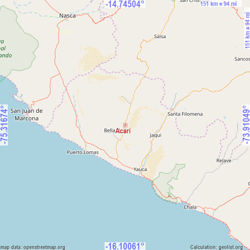
Acarí GPS coordinates[2]
15° 25' 26.148" South, 74° 36' 48.996" West
| Map corner | latitude | longitude |
|---|---|---|
| Upper-left | -14.74504°, | -75.31674° |
| Center: | -15.42393°, | -74.61361° |
| Lower-right: | -16.10061°, | -73.91049° |
| Map W x H: | 150.7×150.7 km | = 93.6×93.6mi |
| max Lat: | -0.96667° ⇑88.9% North |
| Acarí: | -15.42393° |
| min Lat: | ⇓11.1% South -18.01465° |
| min Long | Acarí | max Long |
| -81.30472° | -74.61361° | -69.04167° |
| W 61.1%⇐ | ⇒38.9% E |
Elevation
Elevation of Acarí is 167 m = 548 ft, and this is 2151.7 m = 7059 ft below average elevation for this country.
| Max E: |
5022 m = 16476 ft | 85.6% |
| Avg. | 2318.7 m = 7607 ft | |
| Acarí | 167 m = 548 ft | |
Min E: |
1 m = 3 ft | 14.4% |
See also: Peru elevation on elevation.city.
Geographical zone
Acarí is located in South Torrid zone (between Equator and Tropic of Capricorn). Distance of this Southern Tropic circle is 890.9 km =553.6 mi to South.| Distance of | km | miles | from Acarí |
|---|---|---|---|
| Equator | 1715 | 1065.7 | to North |
| Tropic Capricorn | 890.9 | 553.6 | to South |
| Antarctic Circle | 5686.2 | 3533.2 | to South |
| South Pole | 8292.1 | 5152.5 | to South |


Nearby cities:
15 places around Acarí: (largest is in red/bold)
• Achanizo
81.2 km =50.5 mi,  121°
121°
• Atiquipa
49.3 km =30.6 mi,  147°
147°
• Chala
62.9 km =39.1 mi,  141°
141°
• Chaviña
97 km =60.3 mi,  59°
59°
• Minas de Marcona
58.2 km =36.2 mi,  293°
293°
• Nazca
74.6 km =46.4 mi,  332°
332°
• Pullo
88.5 km =55 mi,  74°
74°
• Puquio
95.6 km =59.4 mi,  32°
32°
• Quicacha
90.2 km =56 mi,  104°
104°
• San Juan
96.8 km =60.1 mi, 27°
• San Juan de Marcona
59.2 km =36.8 mi,  276°
276°
• San Pedro
91.5 km =56.9 mi,  37°
37°
• Tambo Quemado
77.2 km =48 mi,  354°
354°
• Tocota
61.8 km =38.4 mi, 115°
• Yauca
27.9 km =17.3 mi,  160°
160°
Sources, notices
• [Note1] Compared only with cities in Peru existing in our database
• [Src1] Map data: © OpenStreetMap contributors (CC-BY-SA)
• [Src2] Other city data from geonames.org with taken over terms of usage.
• [Src3] Geographical zone / Annual Mean Temperature by Robert A. Rohde @ Wikipedia
