El Ingenio geodata
El Ingenio (Ica) is a seat of a third-order administrative division; located in Peru in America/Lima (GMT-5) time zone. In our database, there are 305 cities with bigger population. Compared to other cities in Peru, 83.2% of cities are located further ↑North; 58.4% of cities are located further ←West and 78.4% of cities have higher elevation than El Ingenio. Note1


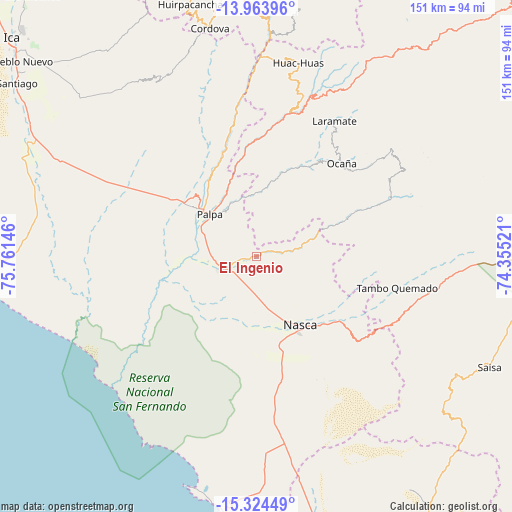
El Ingenio GPS coordinates[2]
14° 38' 43.008" South, 75° 3' 29.988" West
| Map corner | latitude | longitude |
|---|---|---|
| Upper-left | -13.96396°, | -75.76146° |
| Center: | -14.64528°, | -75.05833° |
| Lower-right: | -15.32449°, | -74.35521° |
| Map W x H: | 151.3×151.3 km | = 94×94mi |
| max Lat: | -0.96667° ⇑83.2% North |
| El Ingenio: | -14.64528° |
| min Lat: | ⇓16.8% South -18.01465° |
| min Long | El Ingenio | max Long |
| -81.30472° | -75.05833° | -69.04167° |
| W 58.4%⇐ | ⇒41.6% E |
Elevation
Elevation of El Ingenio is 451 m = 1480 ft, and this is 1867.7 m = 6128 ft below average elevation for this country.
| Max E: |
5022 m = 16476 ft | 78.4% |
| Avg. | 2318.7 m = 7607 ft | |
| El Ingenio | 451 m = 1480 ft | |
Min E: |
1 m = 3 ft | 21.6% |
See also: Peru elevation on elevation.city.
Geographical zone
El Ingenio is located in South Torrid zone (between Equator and Tropic of Capricorn). Distance of this Southern Tropic circle is 977.5 km =607.4 mi to South.| Distance of | km | miles | from El Ingenio |
|---|---|---|---|
| Equator | 1628.4 | 1011.8 | to North |
| Tropic Capricorn | 977.5 | 607.4 | to South |
| Antarctic Circle | 5772.8 | 3587.1 | to South |
| South Pole | 8378.7 | 5206.3 | to South |


Nearby cities:
15 places around El Ingenio: (largest is in red/bold)
• Changuillo
17.9 km =11.1 mi,  263°
263°
• Laramate
48.6 km =30.2 mi,  25°
25°
• Llauta
44.8 km =27.8 mi,  19°
19°
• Llipata
18.4 km =11.4 mi,  299°
299°
• Minas de Marcona
63.3 km =39.3 mi,  185°
185°
• Nazca
24.3 km =15.1 mi,  148°
148°
• Ocaña
39.1 km =24.3 mi,  41°
41°
• Ocoyo
71 km =44.1 mi,  3°
3°
• Ocucaje
73.6 km =45.7 mi, 296°
• Otoca
42.6 km =26.5 mi,  64°
64°
• Palpa
18.5 km =11.5 mi,  312°
312°
• Rosario de Yauca
79.3 km =49.3 mi,  315°
315°
• Río Grande
20.9 km =13 mi, 313°
• Tambo Quemado
41.5 km =25.8 mi,  103°
103°
• Tibillo
62.6 km =38.9 mi,  348°
348°
Sources, notices
• [Note1] Compared only with cities in Peru existing in our database
• [Src1] Map data: © OpenStreetMap contributors (CC-BY-SA)
• [Src2] Other city data from geonames.org with taken over terms of usage.
• [Src3] Geographical zone / Annual Mean Temperature by Robert A. Rohde @ Wikipedia
