Otoca geodata
Otoca (Ayacucho) is a seat of a third-order administrative division; located in Peru in America/Lima (GMT-5) time zone. In our database, there are 305 cities with bigger population. Compared to other cities in Peru, 82.4% of cities are located further ↑North; 60.5% of cities are located further ←West and 62.4% of cities have higher elevation than Otoca. Note1


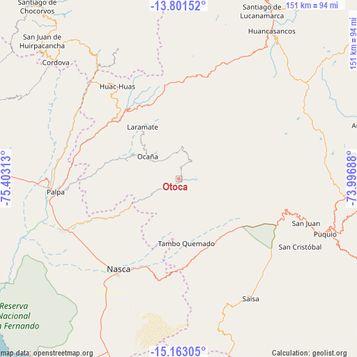
Otoca GPS coordinates[2]
14° 28' 59.988" South, 74° 42' 0" West
| Map corner | latitude | longitude |
|---|---|---|
| Upper-left | -13.80152°, | -75.40313° |
| Center: | -14.48333°, | -74.7° |
| Lower-right: | -15.16305°, | -73.99688° |
| Map W x H: | 151.4×151.4 km | = 94.1×94.1mi |
| max Lat: | -0.96667° ⇑82.4% North |
| Otoca: | -14.48333° |
| min Lat: | ⇓17.6% South -18.01465° |
| min Long | Otoca | max Long |
| -81.30472° | -74.7° | -69.04167° |
| W 60.5%⇐ | ⇒39.5% E |
Elevation
Elevation of Otoca is 2288 m = 7507 ft, and this is 30.7 m = 101 ft below average elevation for this country.
| Max E: |
5022 m = 16476 ft | 62.4% |
| Avg. | 2318.7 m = 7607 ft | |
| Otoca | 2288 m = 7507 ft | |
Min E: |
1 m = 3 ft | 37.6% |
See also: Peru elevation on elevation.city.
Geographical zone
Otoca is located in South Torrid zone (between Equator and Tropic of Capricorn). Distance of this Southern Tropic circle is 995.5 km =618.6 mi to South.| Distance of | km | miles | from Otoca |
|---|---|---|---|
| Equator | 1610.4 | 1000.7 | to North |
| Tropic Capricorn | 995.5 | 618.6 | to South |
| Antarctic Circle | 5790.8 | 3598.2 | to South |
| South Pole | 8396.7 | 5217.5 | to South |


Nearby cities:
15 places around Otoca: (largest is in red/bold)
• Changuillo
59.8 km =37.2 mi,  250°
250°
• El Ingenio
42.6 km =26.5 mi,  244°
244°
• Laramate
31.5 km =19.6 mi,  325°
325°
• Llauta
33.5 km =20.8 mi,  315°
315°
• Llipata
55.4 km =34.4 mi,  260°
260°
• Lucanas
50.1 km =31.1 mi,  104°
104°
• Nazca
46.4 km =28.8 mi,  213°
213°
• Ocaña
16.8 km =10.4 mi,  311°
311°
• Ocoyo
63.2 km =39.3 mi, 326°
• Palpa
52.6 km =32.7 mi, 263°
• Puquio
65.6 km =40.8 mi,  111°
111°
• Río Grande
53.9 km =33.5 mi,  266°
266°
• San Juan
56.9 km =35.4 mi, 109°
• Tambo Quemado
27.9 km =17.3 mi,  176°
176°
• Tibillo
66.8 km =41.5 mi, 310°
Sources, notices
• [Note1] Compared only with cities in Peru existing in our database
• [Src1] Map data: © OpenStreetMap contributors (CC-BY-SA)
• [Src2] Other city data from geonames.org with taken over terms of usage.
• [Src3] Geographical zone / Annual Mean Temperature by Robert A. Rohde @ Wikipedia
