Palpa geodata
Palpa (Ica) is a seat of a third-order administrative division; located in Peru in America/Lima (GMT-5) time zone. With population of 5,883 people, there are 211 cities with bigger population in this country. Compared to other cities in Peru, 82.8% of cities are located further ↑North; 57.1% of cities are located further ←West and 79.8% of cities have higher elevation than Palpa. Note1


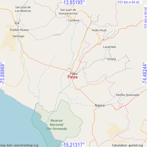
Palpa GPS coordinates[2]
14° 32' 0.996" South, 75° 11' 8.016" West
| Map corner | latitude | longitude |
|---|---|---|
| Upper-left | -13.85195°, | -75.88869° |
| Center: | -14.53361°, | -75.18556° |
| Lower-right: | -15.21317°, | -74.48244° |
| Map W x H: | 151.4×151.4 km | = 94.1×94.1mi |
| max Lat: | -0.96667° ⇑82.8% North |
| Palpa: | -14.53361° |
| min Lat: | ⇓17.2% South -18.01465° |
| min Long | Palpa | max Long |
| -81.30472° | -75.18556° | -69.04167° |
| W 57.1%⇐ | ⇒42.9% E |
Elevation
Elevation of Palpa is 349 m = 1145 ft, and this is 1969.7 m = 6462 ft below average elevation for this country.
| Max E: |
5022 m = 16476 ft | 79.8% |
| Avg. | 2318.7 m = 7607 ft | |
| Palpa | 349 m = 1145 ft | |
Min E: |
1 m = 3 ft | 20.2% |
See also: Peru elevation on elevation.city.
Geographical zone
Palpa is located in South Torrid zone (between Equator and Tropic of Capricorn). Distance of this Southern Tropic circle is 989.9 km =615.1 mi to South.| Distance of | km | miles | from Palpa |
|---|---|---|---|
| Equator | 1616 | 1004.1 | to North |
| Tropic Capricorn | 989.9 | 615.1 | to South |
| Antarctic Circle | 5785.2 | 3594.8 | to South |
| South Pole | 8391.1 | 5214 | to South |


Nearby cities:
15 places around Palpa: (largest is in red/bold)
• Changuillo
15.1 km =9.4 mi,  195°
195°
• El Ingenio
18.5 km =11.5 mi,  132°
132°
• Laramate
46.6 km =29 mi,  47°
47°
• Llauta
41.5 km =25.8 mi,  44°
44°
• Llipata
4.2 km =2.6 mi,  215°
215°
• Nazca
42.4 km =26.3 mi,  141°
141°
• Ocaña
43.1 km =26.8 mi,  67°
67°
• Ocoyo
61 km =37.9 mi,  16°
16°
• Ocucaje
56 km =34.8 mi,  291°
291°
• Otoca
52.6 km =32.7 mi,  83°
83°
• Rosario de Yauca
60.9 km =37.8 mi,  316°
316°
• Río Grande
2.5 km =1.6 mi, 322°
• Santiago
68.6 km =42.6 mi,  304°
304°
• Tambo Quemado
58.4 km =36.3 mi,  112°
112°
• Tibillo
49 km =30.4 mi,  1°
1°
Sources, notices
• [Note1] Compared only with cities in Peru existing in our database
• [Src1] Map data: © OpenStreetMap contributors (CC-BY-SA)
• [Src2] Other city data from geonames.org with taken over terms of usage.
• [Src3] Geographical zone / Annual Mean Temperature by Robert A. Rohde @ Wikipedia
