Marca geodata
Marca (Ancash) is a seat of a third-order administrative division; located in Peru in America/Lima (GMT-5) time zone. In our database, there are 305 cities with bigger population. Compared to other cities in Peru, 60.2% of cities are located further ↓South; 72.4% of cities are located further →East and 56.1% of cities have higher elevation than Marca. Note1


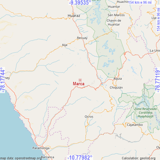
Marca GPS coordinates[2]
10° 5' 17.988" South, 77° 28' 27.516" West
| Map corner | latitude | longitude |
|---|---|---|
| Upper-left | -9.39535°, | -78.17744° |
| Center: | -10.08833°, | -77.47431° |
| Lower-right: | -10.77982°, | -76.77119° |
| Map W x H: | 153.9×153.9 km | = 95.6×95.6mi |
| max Lat: | -0.96667° ⇑39.8% North |
| Marca: | -10.08833° |
| min Lat: | ⇓60.2% South -18.01465° |
| min Long | Marca | max Long |
| -81.30472° | -77.47431° | -69.04167° |
| W 27.6%⇐ | ⇒72.4% E |
Elevation
Elevation of Marca is 2635 m = 8645 ft, and this is 316.3 m = 1038 ft above average elevation for this country.
| Max E: |
5022 m = 16476 ft | 56.1% |
| Marca | 2635 m 8645 ft | |
| Avg. | 2318.7 m = 7607 ft | |
Min E: |
1 m = 3 ft | 43.9% |
See also: Peru elevation on elevation.city.
Geographical zone
Marca is located in South Torrid zone (between Equator and Tropic of Capricorn). Distance of Equator is 1121.7 km =697 mi to North.| Distance of | km | miles | from Marca |
|---|---|---|---|
| Equator | 1121.7 | 697 | to North |
| Tropic Capricorn | 1484.2 | 922.2 | to South |
| Antarctic Circle | 6279.5 | 3901.9 | to South |
| South Pole | 8885.3 | 5521.1 | to South |


Nearby cities:
15 places around Marca: (largest is in red/bold)
• Cajacay
8.3 km =5.2 mi,  152°
152°
• Catac
32.4 km =20.1 mi,  7°
7°
• Chasquitambo
27.3 km =17 mi,  210°
210°
• Congas
27.9 km =17.3 mi,  172°
172°
• Copa
31.6 km =19.6 mi,  182°
182°
• Cotaparaco
16.9 km =10.5 mi,  305°
305°
• Huasta
34.9 km =21.7 mi,  96°
96°
• Huayllapampa
7.7 km =4.8 mi,  303°
303°
• Llacllin
15.8 km =9.8 mi,  278°
278°
• Malvas
29.8 km =18.5 mi, 309°
• Ocros
36 km =22.4 mi, 166°
• Pampas Chico
8.9 km =5.5 mi,  109°
109°
• Succha
34.3 km =21.3 mi,  325°
325°
• Tapacocha
14.4 km =8.9 mi, 303°
• Ticllos
36.1 km =22.4 mi,  120°
120°
Sources, notices
• [Note1] Compared only with cities in Peru existing in our database
• [Src1] Map data: © OpenStreetMap contributors (CC-BY-SA)
• [Src2] Other city data from geonames.org with taken over terms of usage.
• [Src3] Geographical zone / Annual Mean Temperature by Robert A. Rohde @ Wikipedia
