Congas geodata
Congas (Ancash) is a seat of a third-order administrative division; located in Peru in America/Lima (GMT-5) time zone. In our database, there are 305 cities with bigger population. Compared to other cities in Peru, 59% of cities are located further ↓South; 72.1% of cities are located further →East and 56.8% of cities have lower elevation than Congas. Note1


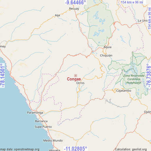
Congas GPS coordinates[2]
10° 20' 13.632" South, 77° 26' 30.768" West
| Map corner | latitude | longitude |
|---|---|---|
| Upper-left | -9.64466°, | -78.14501° |
| Center: | -10.33712°, | -77.44188° |
| Lower-right: | -11.02805°, | -76.73876° |
| Map W x H: | 153.8×153.8 km | = 95.6×95.6mi |
| max Lat: | -0.96667° ⇑41% North |
| Congas: | -10.33712° |
| min Lat: | ⇓59% South -18.01465° |
| min Long | Congas | max Long |
| -81.30472° | -77.44188° | -69.04167° |
| W 27.9%⇐ | ⇒72.1% E |
Elevation
Elevation of Congas is 3078 m = 10098 ft, and this is 759.3 m = 2491 ft above average elevation for this country.
| Max E: |
5022 m = 16476 ft | 43.2% |
| Congas | 3078 m 10098 ft | |
| Avg. | 2318.7 m = 7607 ft | |
Min E: |
1 m = 3 ft | 56.8% |
See also: Peru elevation on elevation.city.
Geographical zone
Congas is located in South Torrid zone (between Equator and Tropic of Capricorn). Distance of Equator is 1149.4 km =714.2 mi to North.| Distance of | km | miles | from Congas |
|---|---|---|---|
| Equator | 1149.4 | 714.2 | to North |
| Tropic Capricorn | 1456.5 | 905 | to South |
| Antarctic Circle | 6251.8 | 3884.7 | to South |
| South Pole | 8857.7 | 5503.9 | to South |


Nearby cities:
15 places around Congas: (largest is in red/bold)
• Acas
18.4 km =11.4 mi,  136°
136°
• Aco
28.2 km =17.5 mi,  129°
129°
• Cajacay
20.2 km =12.6 mi,  0°
0°
• Canis
29.8 km =18.5 mi,  90°
90°
• Chasquitambo
17.8 km =11.1 mi,  283°
283°
• Copa
6.3 km =3.9 mi,  232°
232°
• Corpanqui
27.2 km =16.9 mi,  77°
77°
• Huayllapampa
33.5 km =20.8 mi,  342°
342°
• Llaclla
32.7 km =20.3 mi, 82°
• Llacllin
35.6 km =22.1 mi,  327°
327°
• Llipa
26.3 km =16.3 mi,  100°
100°
• Marca
27.9 km =17.3 mi,  352°
352°
• Ocros
8.8 km =5.5 mi,  145°
145°
• Pampas Chico
25.1 km =15.6 mi,  11°
11°
• Ticllos
29 km =18 mi,  71°
71°
Sources, notices
• [Note1] Compared only with cities in Peru existing in our database
• [Src1] Map data: © OpenStreetMap contributors (CC-BY-SA)
• [Src2] Other city data from geonames.org with taken over terms of usage.
• [Src3] Geographical zone / Annual Mean Temperature by Robert A. Rohde @ Wikipedia
