Huasta geodata
Huasta (Ancash) is a seat of a third-order administrative division; located in Peru in America/Lima (GMT-5) time zone. In our database, there are 305 cities with bigger population. Compared to other cities in Peru, 60.1% of cities are located further ↓South; 69% of cities are located further →East and 57.5% of cities have lower elevation than Huasta. Note1


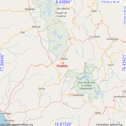
Huasta GPS coordinates[2]
10° 7' 25.86" South, 77° 9' 26.388" West
| Map corner | latitude | longitude |
|---|---|---|
| Upper-left | -9.43094°, | -77.86046° |
| Center: | -10.12385°, | -77.15733° |
| Lower-right: | -10.81526°, | -76.45421° |
| Map W x H: | 153.9×153.9 km | = 95.6×95.6mi |
| max Lat: | -0.96667° ⇑39.9% North |
| Huasta: | -10.12385° |
| min Lat: | ⇓60.1% South -18.01465° |
| min Long | Huasta | max Long |
| -81.30472° | -77.15733° | -69.04167° |
| W 31%⇐ | ⇒69% E |
Elevation
Elevation of Huasta is 3090 m = 10138 ft, and this is 771.3 m = 2531 ft above average elevation for this country.
| Max E: |
5022 m = 16476 ft | 42.5% |
| Huasta | 3090 m 10138 ft | |
| Avg. | 2318.7 m = 7607 ft | |
Min E: |
1 m = 3 ft | 57.5% |
See also: Peru elevation on elevation.city.
Geographical zone
Huasta is located in South Torrid zone (between Equator and Tropic of Capricorn). Distance of Equator is 1125.7 km =699.5 mi to North.| Distance of | km | miles | from Huasta |
|---|---|---|---|
| Equator | 1125.7 | 699.5 | to North |
| Tropic Capricorn | 1480.3 | 919.8 | to South |
| Antarctic Circle | 6275.5 | 3899.4 | to South |
| South Pole | 8881.4 | 5518.6 | to South |


Nearby cities:
15 places around Huasta: (largest is in red/bold)
• Aquia
5.7 km =3.5 mi,  14°
14°
• Cajacay
31.1 km =19.3 mi,  263°
263°
• Canis
24 km =14.9 mi,  183°
183°
• Congas
39.1 km =24.3 mi,  232°
232°
• Copa
30.6 km =19 mi,  163°
163°
• Corpanqui
18.5 km =11.5 mi,  194°
194°
• Huallanca
34.5 km =21.4 mi,  43°
43°
• Llaclla
19.5 km =12.1 mi, 176°
• Llipa
29.2 km =18.1 mi, 190°
• Mangas
28.5 km =17.7 mi,  167°
167°
• Marca
34.9 km =21.7 mi,  276°
276°
• Ocros
40.6 km =25.2 mi,  220°
220°
• Pampas Chico
26.3 km =16.3 mi,  272°
272°
• Queropalca
39.2 km =24.4 mi,  99°
99°
• Ticllos
14.9 km =9.3 mi, 194°
Sources, notices
• [Note1] Compared only with cities in Peru existing in our database
• [Src1] Map data: © OpenStreetMap contributors (CC-BY-SA)
• [Src2] Other city data from geonames.org with taken over terms of usage.
• [Src3] Geographical zone / Annual Mean Temperature by Robert A. Rohde @ Wikipedia
