Maranganí geodata
Maranganí (Cusco) is a populated place; located in Peru in America/Lima (GMT-5) time zone. With population of 3,709 people, there are 281 cities with bigger population in this country. Compared to other cities in Peru, 80.9% of cities are located further ↑North; 89.2% of cities are located further ←West and 86.3% of cities have lower elevation than Maranganí. Note1


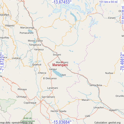
Maranganí GPS coordinates[2]
14° 21' 24.192" South, 71° 10' 9.264" West
| Map corner | latitude | longitude |
|---|---|---|
| Upper-left | -13.67453°, | -71.87237° |
| Center: | -14.35672°, | -71.16924° |
| Lower-right: | -15.03684°, | -70.46612° |
| Map W x H: | 151.5×151.5 km | = 94.1×94.1mi |
| max Lat: | -0.96667° ⇑80.9% North |
| Maranganí: | -14.35672° |
| min Lat: | ⇓19.1% South -18.01465° |
| min Long | Maranganí | max Long |
| -81.30472° | -71.16924° | -69.04167° |
| W 89.2%⇐ | ⇒10.8% E |
Elevation
Elevation of Maranganí is 3701 m = 12142 ft, and this is 1382.3 m = 4535 ft above average elevation for this country.
| Max E: |
5022 m = 16476 ft | 13.7% |
| Maranganí | 3701 m 12142 ft | |
| Avg. | 2318.7 m = 7607 ft | |
Min E: |
1 m = 3 ft | 86.3% |
See also: Peru elevation on elevation.city.
Geographical zone
Maranganí is located in South Torrid zone (between Equator and Tropic of Capricorn). Distance of this Southern Tropic circle is 1009.6 km =627.3 mi to South.| Distance of | km | miles | from Maranganí |
|---|---|---|---|
| Equator | 1596.3 | 991.9 | to North |
| Tropic Capricorn | 1009.6 | 627.3 | to South |
| Antarctic Circle | 5804.9 | 3607 | to South |
| South Pole | 8410.7 | 5226.2 | to South |


Nearby cities:
15 places around Maranganí: (largest is in red/bold)
• Cahuanuyo
31.7 km =19.7 mi,  273°
273°
• Callanca
19.7 km =12.2 mi,  8°
8°
• Ccaquiracunca
31.6 km =19.6 mi,  286°
286°
• Checca
27.4 km =17 mi,  241°
241°
• Conchopata
12.9 km =8 mi,  194°
194°
• El Descanso
24.5 km =15.2 mi,  216°
216°
• Huayna Alcalde
12.5 km =7.8 mi,  39°
39°
• Langui
14 km =8.7 mi,  233°
233°
• Layo
15.3 km =9.5 mi,  174°
174°
• Mosoc Cancha
11.9 km =7.4 mi,  47°
47°
• Quehue
30.9 km =19.2 mi, 265°
• Queromarca
30 km =18.6 mi,  309°
309°
• San Pablo
23.3 km =14.5 mi,  317°
317°
• San Pedro
26.5 km =16.5 mi, 315°
• Sicuani
11.5 km =7.1 mi,  327°
327°
Sources, notices
• [Note1] Compared only with cities in Peru existing in our database
• [Src1] Map data: © OpenStreetMap contributors (CC-BY-SA)
• [Src2] Other city data from geonames.org with taken over terms of usage.
• [Src3] Geographical zone / Annual Mean Temperature by Robert A. Rohde @ Wikipedia
