Tapay geodata
Tapay (Arequipa) is a seat of a third-order administrative division; located in Peru in America/Lima (GMT-5) time zone. In our database, there are 305 cities with bigger population. Compared to other cities in Peru, 90.1% of cities are located further ↑North; 81.3% of cities are located further ←West and 53.6% of cities have lower elevation than Tapay. Note1


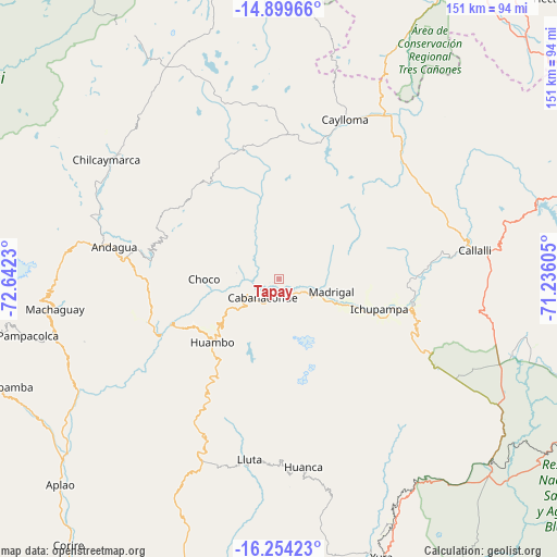
Tapay GPS coordinates[2]
15° 34' 41.016" South, 71° 56' 21.012" West
| Map corner | latitude | longitude |
|---|---|---|
| Upper-left | -14.89966°, | -72.6423° |
| Center: | -15.57806°, | -71.93917° |
| Lower-right: | -16.25423°, | -71.23605° |
| Map W x H: | 150.6×150.6 km | = 93.6×93.6mi |
| max Lat: | -0.96667° ⇑90.1% North |
| Tapay: | -15.57806° |
| min Lat: | ⇓9.9% South -18.01465° |
| min Long | Tapay | max Long |
| -81.30472° | -71.93917° | -69.04167° |
| W 81.3%⇐ | ⇒18.7% E |
Elevation
Elevation of Tapay is 2989 m = 9806 ft, and this is 670.3 m = 2199 ft above average elevation for this country.
| Max E: |
5022 m = 16476 ft | 46.4% |
| Tapay | 2989 m 9806 ft | |
| Avg. | 2318.7 m = 7607 ft | |
Min E: |
1 m = 3 ft | 53.6% |
See also: Peru elevation on elevation.city.
Geographical zone
Tapay is located in South Torrid zone (between Equator and Tropic of Capricorn). Distance of this Southern Tropic circle is 873.8 km =543 mi to South.| Distance of | km | miles | from Tapay |
|---|---|---|---|
| Equator | 1732.1 | 1076.3 | to North |
| Tropic Capricorn | 873.8 | 543 | to South |
| Antarctic Circle | 5669.1 | 3522.6 | to South |
| South Pole | 8274.9 | 5141.8 | to South |


Nearby cities:
15 places around Tapay: (largest is in red/bold)
• Achoma
27.1 km =16.8 mi,  109°
109°
• Ayo
37.7 km =23.4 mi,  252°
252°
• Cabanaconde
6.4 km =4 mi,  221°
221°
• Ccolo
48.6 km =30.2 mi,  80°
80°
• Chivay
36.8 km =22.9 mi,  100°
100°
• Choco
20.4 km =12.7 mi,  270°
270°
• Coporaque
31.9 km =19.8 mi, 99°
• Huambo
24.8 km =15.4 mi,  226°
226°
• Ichupampa
28.1 km =17.5 mi, 106°
• Lari
18.9 km =11.7 mi, 105°
• Lluta
49.2 km =30.6 mi,  189°
189°
• Maca
19.5 km =12.1 mi, 111°
• Madrigal
14.4 km =8.9 mi, 103°
• Tuti
41.9 km =26 mi, 83°
• Yanque
31.2 km =19.4 mi, 104°
Sources, notices
• [Note1] Compared only with cities in Peru existing in our database
• [Src1] Map data: © OpenStreetMap contributors (CC-BY-SA)
• [Src2] Other city data from geonames.org with taken over terms of usage.
• [Src3] Geographical zone / Annual Mean Temperature by Robert A. Rohde @ Wikipedia
