Carumas geodata
Carumas (Moquegua) is a seat of a third-order administrative division; located in Peru in America/Lima (GMT-5) time zone. In our database, there are 305 cities with bigger population. Compared to other cities in Peru, 97.1% of cities are located further ↑North; 91.5% of cities are located further ←West and 81.3% of cities have lower elevation than Carumas. Note1


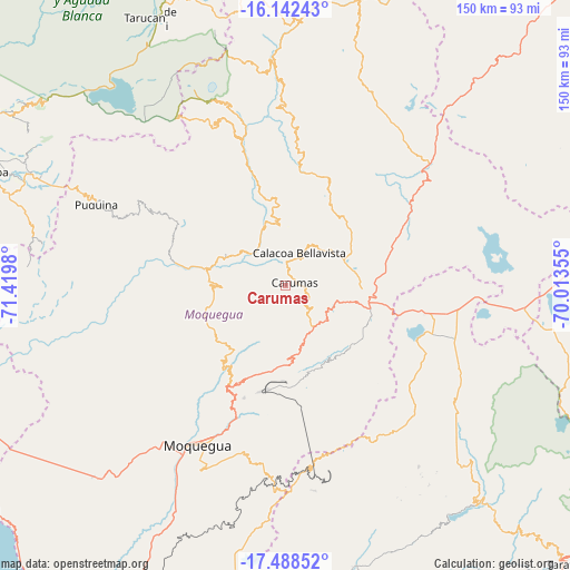
Carumas GPS coordinates[2]
16° 49' 0.012" South, 70° 43' 0.012" West
| Map corner | latitude | longitude |
|---|---|---|
| Upper-left | -16.14243°, | -71.4198° |
| Center: | -16.81667°, | -70.71667° |
| Lower-right: | -17.48852°, | -70.01355° |
| Map W x H: | 149.7×149.7 km | = 93×93mi |
| max Lat: | -0.96667° ⇑97.1% North |
| Carumas: | -16.81667° |
| min Lat: | ⇓2.9% South -18.01465° |
| min Long | Carumas | max Long |
| -81.30472° | -70.71667° | -69.04167° |
| W 91.5%⇐ | ⇒8.5% E |
Elevation
Elevation of Carumas is 3552 m = 11654 ft, and this is 1233.3 m = 4046 ft above average elevation for this country.
| Max E: |
5022 m = 16476 ft | 18.7% |
| Carumas | 3552 m 11654 ft | |
| Avg. | 2318.7 m = 7607 ft | |
Min E: |
1 m = 3 ft | 81.3% |
See also: Peru elevation on elevation.city.
Geographical zone
Carumas is located in South Torrid zone (between Equator and Tropic of Capricorn). Distance of this Southern Tropic circle is 736.1 km =457.4 mi to South.| Distance of | km | miles | from Carumas |
|---|---|---|---|
| Equator | 1869.8 | 1161.8 | to North |
| Tropic Capricorn | 736.1 | 457.4 | to South |
| Antarctic Circle | 5531.3 | 3437 | to South |
| South Pole | 8137.2 | 5056.2 | to South |


Nearby cities:
15 places around Carumas: (largest is in red/bold)
• Calacoa
7.6 km =4.7 mi,  13°
13°
• Chojata
46.4 km =28.8 mi,  357°
357°
• Coalaque
37.3 km =23.2 mi,  299°
299°
• Cuchumbaya
8.2 km =5.1 mi,  25°
25°
• La Capilla
49.7 km =30.9 mi,  277°
277°
• Lloque
53.8 km =33.4 mi, 358°
• Matalaque
38.6 km =24 mi,  343°
343°
• Moquegua
48.4 km =30.1 mi,  208°
208°
• Omate
32 km =19.9 mi, 297°
• Pujocucho
54.2 km =33.7 mi,  134°
134°
• Puquina
54.2 km =33.7 mi,  293°
293°
• Quinistaquillas
19.2 km =11.9 mi, 292°
• Samegua
44.7 km =27.8 mi, 205°
• Torata
31.9 km =19.8 mi,  204°
204°
• Ubinas
49 km =30.4 mi, 340°
Sources, notices
• [Note1] Compared only with cities in Peru existing in our database
• [Src1] Map data: © OpenStreetMap contributors (CC-BY-SA)
• [Src2] Other city data from geonames.org with taken over terms of usage.
• [Src3] Geographical zone / Annual Mean Temperature by Robert A. Rohde @ Wikipedia
