Torata geodata
Torata (Moquegua) is a seat of a third-order administrative division; located in Peru in America/Lima (GMT-5) time zone. With population of 7,054 people, there are 185 cities with bigger population in this country. Compared to other cities in Peru, 97.3% of cities are located further ↑North; 90.9% of cities are located further ←West and 63.2% of cities have higher elevation than Torata. Note1


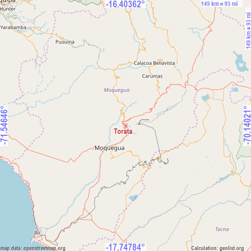
Torata GPS coordinates[2]
17° 4' 36.984" South, 70° 50' 35.988" West
| Map corner | latitude | longitude |
|---|---|---|
| Upper-left | -16.40362°, | -71.54646° |
| Center: | -17.07694°, | -70.84333° |
| Lower-right: | -17.74784°, | -70.14021° |
| Map W x H: | 149.5×149.5 km | = 92.9×92.9mi |
| max Lat: | -0.96667° ⇑97.3% North |
| Torata: | -17.07694° |
| min Lat: | ⇓2.7% South -18.01465° |
| min Long | Torata | max Long |
| -81.30472° | -70.84333° | -69.04167° |
| W 90.9%⇐ | ⇒9.1% E |
Elevation
Elevation of Torata is 2213 m = 7260 ft, and this is 105.7 m = 347 ft below average elevation for this country.
| Max E: |
5022 m = 16476 ft | 63.2% |
| Avg. | 2318.7 m = 7607 ft | |
| Torata | 2213 m = 7260 ft | |
Min E: |
1 m = 3 ft | 36.8% |
See also: Peru elevation on elevation.city.
Geographical zone
Torata is located in South Torrid zone (between Equator and Tropic of Capricorn). Distance of this Southern Tropic circle is 707.1 km =439.4 mi to South.| Distance of | km | miles | from Torata |
|---|---|---|---|
| Equator | 1898.8 | 1179.9 | to North |
| Tropic Capricorn | 707.1 | 439.4 | to South |
| Antarctic Circle | 5502.4 | 3419 | to South |
| South Pole | 8108.3 | 5038.3 | to South |


Nearby cities:
15 places around Torata: (largest is in red/bold)
• Cairani
56 km =34.8 mi,  114°
114°
• Calacoa
39.4 km =24.5 mi,  22°
22°
• Camilaca
53.8 km =33.4 mi, 113°
• Carumas
31.9 km =19.8 mi, 24°
• Coalaque
51.1 km =31.8 mi,  338°
338°
• Cuchumbaya
40.1 km =24.9 mi,  25°
25°
• Huanuara
61.3 km =38.1 mi,  115°
115°
• Ilabaya
51.9 km =32.2 mi,  137°
137°
• La Capilla
50.4 km =31.3 mi,  314°
314°
• Locumba
60.3 km =37.5 mi,  171°
171°
• Moquegua
16.7 km =10.4 mi,  216°
216°
• Omate
46.2 km =28.7 mi, 341°
• Pujocucho
53 km =32.9 mi,  99°
99°
• Quinistaquillas
36.6 km =22.7 mi,  353°
353°
• Samegua
12.8 km =8 mi,  207°
207°
Sources, notices
• [Note1] Compared only with cities in Peru existing in our database
• [Src1] Map data: © OpenStreetMap contributors (CC-BY-SA)
• [Src2] Other city data from geonames.org with taken over terms of usage.
• [Src3] Geographical zone / Annual Mean Temperature by Robert A. Rohde @ Wikipedia
