Pampachiri geodata
Pampachiri (Apurímac) is a seat of a third-order administrative division; located in Peru in America/Lima (GMT-5) time zone. In our database, there are 305 cities with bigger population. Compared to other cities in Peru, 78.3% of cities are located further ↑North; 69.9% of cities are located further ←West and 72.3% of cities have lower elevation than Pampachiri. Note1


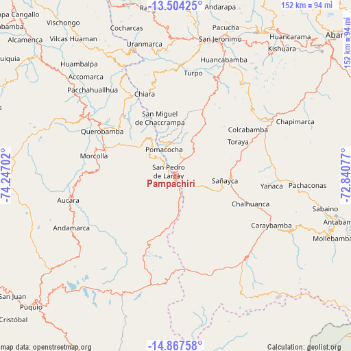
Pampachiri GPS coordinates[2]
14° 11' 12.984" South, 73° 32' 38.004" West
| Map corner | latitude | longitude |
|---|---|---|
| Upper-left | -13.50425°, | -74.24702° |
| Center: | -14.18694°, | -73.54389° |
| Lower-right: | -14.86758°, | -72.84077° |
| Map W x H: | 151.6×151.6 km | = 94.2×94.2mi |
| max Lat: | -0.96667° ⇑78.3% North |
| Pampachiri: | -14.18694° |
| min Lat: | ⇓21.7% South -18.01465° |
| min Long | Pampachiri | max Long |
| -81.30472° | -73.54389° | -69.04167° |
| W 69.9%⇐ | ⇒30.1% E |
Elevation
Elevation of Pampachiri is 3384 m = 11102 ft, and this is 1065.3 m = 3495 ft above average elevation for this country.
| Max E: |
5022 m = 16476 ft | 27.7% |
| Pampachiri | 3384 m 11102 ft | |
| Avg. | 2318.7 m = 7607 ft | |
Min E: |
1 m = 3 ft | 72.3% |
See also: Peru elevation on elevation.city.
Geographical zone
Pampachiri is located in South Torrid zone (between Equator and Tropic of Capricorn). Distance of this Southern Tropic circle is 1028.5 km =639.1 mi to South.| Distance of | km | miles | from Pampachiri |
|---|---|---|---|
| Equator | 1577.4 | 980.2 | to North |
| Tropic Capricorn | 1028.5 | 639.1 | to South |
| Antarctic Circle | 5823.7 | 3618.7 | to South |
| South Pole | 8429.6 | 5237.9 | to South |


Nearby cities:
15 places around Pampachiri: (largest is in red/bold)
• Capaya
25.5 km =15.8 mi,  72°
72°
• Chaccrampa
26.2 km =16.3 mi,  344°
344°
• Chalhuanca
36 km =22.4 mi,  110°
110°
• Huacaña
37 km =23 mi,  272°
272°
• Huayana
17 km =10.6 mi, 335°
• Huayllo
30.3 km =18.8 mi,  78°
78°
• Morcolla
36.3 km =22.6 mi,  283°
283°
• Paico
19.8 km =12.3 mi,  327°
327°
• Pomacocha
12.4 km =7.7 mi, 336°
• Querobamba
37.3 km =23.2 mi,  301°
301°
• Sañayca
22.6 km =14 mi,  95°
95°
• Soras
10.3 km =6.4 mi,  320°
320°
• Soraya
25.1 km =15.6 mi, 83°
• Toraya
30.6 km =19 mi,  60°
60°
• Umamarca
15.1 km =9.4 mi,  351°
351°
Sources, notices
• [Note1] Compared only with cities in Peru existing in our database
• [Src1] Map data: © OpenStreetMap contributors (CC-BY-SA)
• [Src2] Other city data from geonames.org with taken over terms of usage.
• [Src3] Geographical zone / Annual Mean Temperature by Robert A. Rohde @ Wikipedia
