Toraya geodata
Toraya (Apurímac) is a seat of a third-order administrative division; located in Peru in America/Lima (GMT-5) time zone. In our database, there are 305 cities with bigger population. Compared to other cities in Peru, 74.7% of cities are located further ↑North; 71.4% of cities are located further ←West and 60.7% of cities have lower elevation than Toraya. Note1


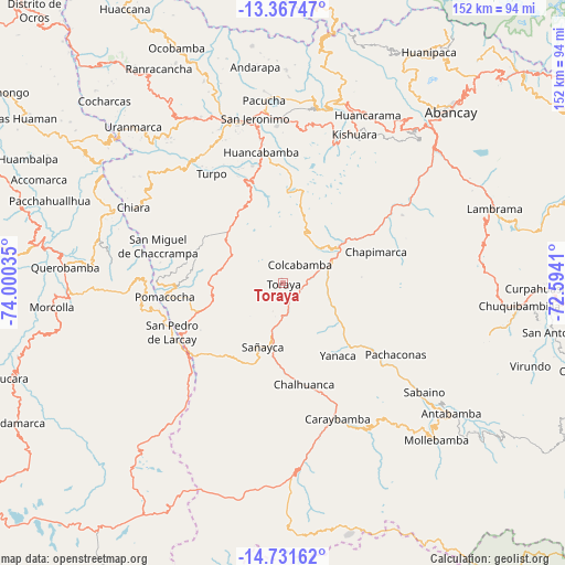
Toraya GPS coordinates[2]
14° 3' 2.016" South, 73° 17' 49.992" West
| Map corner | latitude | longitude |
|---|---|---|
| Upper-left | -13.36747°, | -74.00035° |
| Center: | -14.05056°, | -73.29722° |
| Lower-right: | -14.73162°, | -72.5941° |
| Map W x H: | 151.7×151.7 km | = 94.3×94.3mi |
| max Lat: | -0.96667° ⇑74.7% North |
| Toraya: | -14.05056° |
| min Lat: | ⇓25.3% South -18.01465° |
| min Long | Toraya | max Long |
| -81.30472° | -73.29722° | -69.04167° |
| W 71.4%⇐ | ⇒28.6% E |
Elevation
Elevation of Toraya is 3171 m = 10404 ft, and this is 852.3 m = 2796 ft above average elevation for this country.
| Max E: |
5022 m = 16476 ft | 39.3% |
| Toraya | 3171 m 10404 ft | |
| Avg. | 2318.7 m = 7607 ft | |
Min E: |
1 m = 3 ft | 60.7% |
See also: Peru elevation on elevation.city.
Geographical zone
Toraya is located in South Torrid zone (between Equator and Tropic of Capricorn). Distance of this Southern Tropic circle is 1043.6 km =648.5 mi to South.| Distance of | km | miles | from Toraya |
|---|---|---|---|
| Equator | 1562.3 | 970.8 | to North |
| Tropic Capricorn | 1043.6 | 648.5 | to South |
| Antarctic Circle | 5838.9 | 3628.1 | to South |
| South Pole | 8444.8 | 5247.4 | to South |


Nearby cities:
15 places around Toraya: (largest is in red/bold)
• Ayahuay
30.4 km =18.9 mi,  125°
125°
• Capaya
8 km =5 mi,  196°
196°
• Chalhuanca
28.7 km =17.8 mi,  165°
165°
• Chapimarca
26.4 km =16.4 mi,  71°
71°
• Colcabamba
7.1 km =4.4 mi,  48°
48°
• Huayllo
9.6 km =6 mi,  161°
161°
• Lucre
13.6 km =8.5 mi,  34°
34°
• Pampachiri
30.6 km =19 mi,  240°
240°
• Pocohuanca
29.5 km =18.3 mi, 128°
• Sañayca
17.9 km =11.1 mi,  193°
193°
• Soraya
12.6 km =7.8 mi, 187°
• Tapairihua
19.4 km =12.1 mi,  120°
120°
• Tintay
15.7 km =9.8 mi, 49°
• Umamarca
28.9 km =18 mi,  269°
269°
• Yanaca
25.1 km =15.6 mi,  137°
137°
Sources, notices
• [Note1] Compared only with cities in Peru existing in our database
• [Src1] Map data: © OpenStreetMap contributors (CC-BY-SA)
• [Src2] Other city data from geonames.org with taken over terms of usage.
• [Src3] Geographical zone / Annual Mean Temperature by Robert A. Rohde @ Wikipedia
