El Cardo geodata
El Cardo (Arequipa) is a seat of a third-order administrative division; located in Peru in America/Lima (GMT-5) time zone. In our database, there are 305 cities with bigger population. Compared to other cities in Peru, 96.1% of cities are located further ↑North; 75.4% of cities are located further ←West and 95.8% of cities have higher elevation than El Cardo. Note1
Administrative division(s):
- Level 1: Arequipa
- Level 2: Provincia de Camaná
- Level 3: Jose Maria Quimper


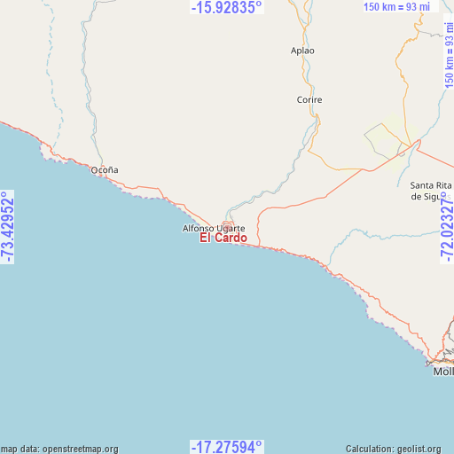
El Cardo GPS coordinates[2]
16° 36' 11.988" South, 72° 43' 35.004" West
| Map corner | latitude | longitude |
|---|---|---|
| Upper-left | -15.92835°, | -73.42952° |
| Center: | -16.60333°, | -72.72639° |
| Lower-right: | -17.27594°, | -72.02327° |
| Map W x H: | 149.8×149.8 km | = 93.1×93.1mi |
| max Lat: | -0.96667° ⇑96.1% North |
| El Cardo: | -16.60333° |
| min Lat: | ⇓3.9% South -18.01465° |
| min Long | El Cardo | max Long |
| -81.30472° | -72.72639° | -69.04167° |
| W 75.4%⇐ | ⇒24.6% E |
Elevation
Elevation of El Cardo is 25 m = 82 ft, and this is 2293.7 m = 7525 ft below average elevation for this country.
| Max E: |
5022 m = 16476 ft | 95.8% |
| Avg. | 2318.7 m = 7607 ft | |
| El Cardo | 25 m = 82 ft | |
Min E: |
1 m = 3 ft | 4.2% |
See also: Peru elevation on elevation.city.
Geographical zone
El Cardo is located in South Torrid zone (between Equator and Tropic of Capricorn). Distance of this Southern Tropic circle is 759.8 km =472.1 mi to South.| Distance of | km | miles | from El Cardo |
|---|---|---|---|
| Equator | 1846.1 | 1147.1 | to North |
| Tropic Capricorn | 759.8 | 472.1 | to South |
| Antarctic Circle | 5555.1 | 3451.8 | to South |
| South Pole | 8160.9 | 5070.9 | to South |


Nearby cities:
15 places around El Cardo: (largest is in red/bold)
• Andaray
90.8 km =56.4 mi,  350°
350°
• Aplao
63.7 km =39.6 mi,  22°
22°
• Camaná
2.8 km =1.7 mi,  143°
143°
• Chuquibamba
85.4 km =53.1 mi,  5°
5°
• Corire
50.2 km =31.2 mi,  32°
32°
• Huancarqui
62.6 km =38.9 mi, 25°
• Iquipi
85.4 km =53.1 mi,  329°
329°
• Iray
83.7 km =52 mi, 7°
• La Pampa
3.4 km =2.1 mi,  109°
109°
• Mollendo
89 km =55.3 mi,  121°
121°
• Ocoña
44.8 km =27.8 mi,  294°
294°
• Pampacolca
100.3 km =62.3 mi, 9°
• Quilca
33.4 km =20.8 mi, 111°
• Urasqui
79.6 km =49.5 mi,  323°
323°
• Yanaquihua
93.6 km =58.2 mi, 350°
Sources, notices
• [Note1] Compared only with cities in Peru existing in our database
• [Src1] Map data: © OpenStreetMap contributors (CC-BY-SA)
• [Src2] Other city data from geonames.org with taken over terms of usage.
• [Src3] Geographical zone / Annual Mean Temperature by Robert A. Rohde @ Wikipedia
