Quilca geodata
Quilca (Arequipa) is a seat of a third-order administrative division; located in Peru in America/Lima (GMT-5) time zone. In our database, there are 305 cities with bigger population. Compared to other cities in Peru, 96.6% of cities are located further ↑North; 78% of cities are located further ←West and 98.8% of cities have higher elevation than Quilca. Note1


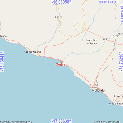
Quilca GPS coordinates[2]
16° 42' 51.012" South, 72° 26' 7.008" West
| Map corner | latitude | longitude |
|---|---|---|
| Upper-left | -16.03958°, | -73.13841° |
| Center: | -16.71417°, | -72.43528° |
| Lower-right: | -17.38639°, | -71.73216° |
| Map W x H: | 149.8×149.8 km | = 93.1×93.1mi |
| max Lat: | -0.96667° ⇑96.6% North |
| Quilca: | -16.71417° |
| min Lat: | ⇓3.4% South -18.01465° |
| min Long | Quilca | max Long |
| -81.30472° | -72.43528° | -69.04167° |
| W 78%⇐ | ⇒22% E |
Elevation
Elevation of Quilca is 11 m = 36 ft, and this is 2307.7 m = 7571 ft below average elevation for this country.
| Max E: |
5022 m = 16476 ft | 98.8% |
| Avg. | 2318.7 m = 7607 ft | |
| Quilca | 11 m = 36 ft | |
Min E: |
1 m = 3 ft | 1.2% |
See also: Peru elevation on elevation.city.
Geographical zone
Quilca is located in South Torrid zone (between Equator and Tropic of Capricorn). Distance of this Southern Tropic circle is 747.5 km =464.5 mi to South.| Distance of | km | miles | from Quilca |
|---|---|---|---|
| Equator | 1858.4 | 1154.8 | to North |
| Tropic Capricorn | 747.5 | 464.5 | to South |
| Antarctic Circle | 5542.7 | 3444.1 | to South |
| South Pole | 8148.6 | 5063.3 | to South |


Nearby cities:
15 places around Quilca: (largest is in red/bold)
• Aplao
71.3 km =44.3 mi,  354°
354°
• Camaná
31 km =19.3 mi,  288°
288°
• Cocachacra
83.2 km =51.7 mi,  119°
119°
• Corire
54.7 km =34 mi,  355°
355°
• El Cardo
33.4 km =20.8 mi, 291°
• Huancarqui
68.9 km =42.8 mi, 356°
• La Curva
81.1 km =50.4 mi,  126°
126°
• La Pampa
30 km =18.6 mi, 291°
• Lluta
89.8 km =55.8 mi,  30°
30°
• Mollendo
56.4 km =35 mi, 127°
• Ocoña
78.2 km =48.6 mi, 293°
• Punta de Bombón
85.2 km =52.9 mi, 126°
• Tiabaya
94.7 km =58.8 mi,  71°
71°
• Uchumayo
87.5 km =54.4 mi, 68°
• Yura
95.5 km =59.3 mi,  57°
57°
Sources, notices
• [Note1] Compared only with cities in Peru existing in our database
• [Src1] Map data: © OpenStreetMap contributors (CC-BY-SA)
• [Src2] Other city data from geonames.org with taken over terms of usage.
• [Src3] Geographical zone / Annual Mean Temperature by Robert A. Rohde @ Wikipedia
