Camaná geodata
Camaná (Arequipa) is a populated place; located in Peru in America/Lima (GMT-5) time zone. With population of 16,434 people, there are 94 cities with bigger population in this country. Compared to other cities in Peru, 96.4% of cities are located further ↑North; 75.6% of cities are located further ←West and 97.2% of cities have higher elevation than Camaná. Note1


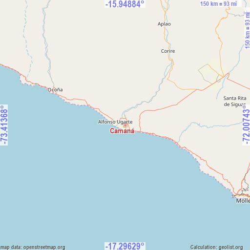
Camaná GPS coordinates[2]
16° 37' 25.5" South, 72° 42' 37.98" West
| Map corner | latitude | longitude |
|---|---|---|
| Upper-left | -15.94884°, | -73.41368° |
| Center: | -16.62375°, | -72.71055° |
| Lower-right: | -17.29629°, | -72.00743° |
| Map W x H: | 149.8×149.8 km | = 93.1×93.1mi |
| max Lat: | -0.96667° ⇑96.4% North |
| Camaná: | -16.62375° |
| min Lat: | ⇓3.6% South -18.01465° |
| min Long | Camaná | max Long |
| -81.30472° | -72.71055° | -69.04167° |
| W 75.6%⇐ | ⇒24.4% E |
Elevation
Elevation of Camaná is 16 m = 52 ft, and this is 2302.7 m = 7555 ft below average elevation for this country.
| Max E: |
5022 m = 16476 ft | 97.2% |
| Avg. | 2318.7 m = 7607 ft | |
| Camaná | 16 m = 52 ft | |
Min E: |
1 m = 3 ft | 2.8% |
See also: Peru elevation on elevation.city.
Geographical zone
Camaná is located in South Torrid zone (between Equator and Tropic of Capricorn). Distance of this Southern Tropic circle is 757.5 km =470.7 mi to South.| Distance of | km | miles | from Camaná |
|---|---|---|---|
| Equator | 1848.4 | 1148.5 | to North |
| Tropic Capricorn | 757.5 | 470.7 | to South |
| Antarctic Circle | 5552.8 | 3450.3 | to South |
| South Pole | 8158.7 | 5069.6 | to South |


Nearby cities:
15 places around Camaná: (largest is in red/bold)
• Andaray
93.3 km =58 mi,  350°
350°
• Aplao
65.2 km =40.5 mi,  20°
20°
• Chuquibamba
87.6 km =54.4 mi,  3°
3°
• Corire
51.3 km =31.9 mi,  29°
29°
• El Cardo
2.8 km =1.7 mi,  323°
323°
• Huancarqui
63.9 km =39.7 mi, 23°
• Iquipi
88.2 km =54.8 mi,  329°
329°
• Iray
85.8 km =53.3 mi,  6°
6°
• La Pampa
1.9 km =1.2 mi,  53°
53°
• Lluta
100.5 km =62.4 mi, 47°
• Mollendo
86.3 km =53.6 mi,  120°
120°
• Ocoña
47.4 km =29.5 mi,  296°
296°
• Quilca
31 km =19.3 mi,  108°
108°
• Urasqui
82.4 km =51.2 mi, 323°
• Yanaquihua
96.1 km =59.7 mi, 349°
Sources, notices
• [Note1] Compared only with cities in Peru existing in our database
• [Src1] Map data: © OpenStreetMap contributors (CC-BY-SA)
• [Src2] Other city data from geonames.org with taken over terms of usage.
• [Src3] Geographical zone / Annual Mean Temperature by Robert A. Rohde @ Wikipedia
