Acas geodata
Acas (Ancash) is a seat of a third-order administrative division; located in Peru in America/Lima (GMT-5) time zone. In our database, there are 305 cities with bigger population. Compared to other cities in Peru, 57.9% of cities are located further ↓South; 70.7% of cities are located further →East and 86.2% of cities have lower elevation than Acas. Note1


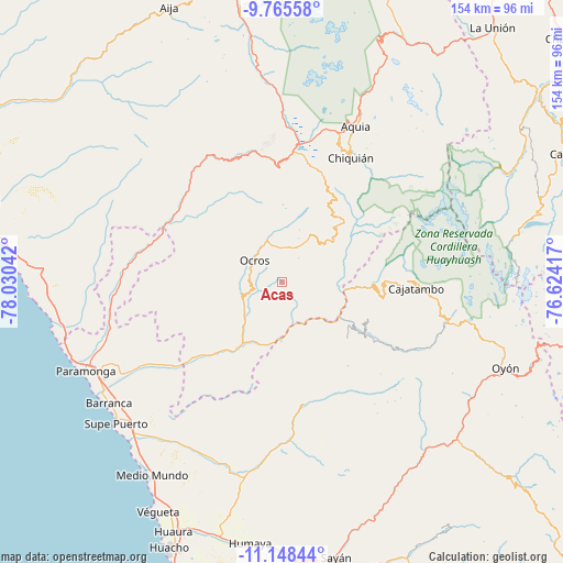
Acas GPS coordinates[2]
10° 27' 28.008" South, 77° 19' 38.244" West
| Map corner | latitude | longitude |
|---|---|---|
| Upper-left | -9.76558°, | -78.03042° |
| Center: | -10.45778°, | -77.32729° |
| Lower-right: | -11.14844°, | -76.62417° |
| Map W x H: | 153.8×153.8 km | = 95.6×95.6mi |
| max Lat: | -0.96667° ⇑42.1% North |
| Acas: | -10.45778° |
| min Lat: | ⇓57.9% South -18.01465° |
| min Long | Acas | max Long |
| -81.30472° | -77.32729° | -69.04167° |
| W 29.3%⇐ | ⇒70.7% E |
Elevation
Elevation of Acas is 3700 m = 12139 ft, and this is 1381.3 m = 4532 ft above average elevation for this country.
| Max E: |
5022 m = 16476 ft | 13.8% |
| Acas | 3700 m 12139 ft | |
| Avg. | 2318.7 m = 7607 ft | |
Min E: |
1 m = 3 ft | 86.2% |
See also: Peru elevation on elevation.city.
Geographical zone
Acas is located in South Torrid zone (between Equator and Tropic of Capricorn). Distance of Equator is 1162.8 km =722.5 mi to North.| Distance of | km | miles | from Acas |
|---|---|---|---|
| Equator | 1162.8 | 722.5 | to North |
| Tropic Capricorn | 1443.1 | 896.7 | to South |
| Antarctic Circle | 6238.4 | 3876.4 | to South |
| South Pole | 8844.3 | 5495.6 | to South |


Nearby cities:
15 places around Acas: (largest is in red/bold)
• Aco
10.4 km =6.5 mi,  115°
115°
• Ambar
31.3 km =19.4 mi,  167°
167°
• Cajacay
35.8 km =22.2 mi,  339°
339°
• Canis
21.7 km =13.5 mi,  52°
52°
• Chasquitambo
34.6 km =21.5 mi,  300°
300°
• Congas
18.4 km =11.4 mi,  316°
316°
• Copa
20 km =12.4 mi, 298°
• Copa
28.2 km =17.5 mi,  74°
74°
• Corpanqui
23.8 km =14.8 mi,  36°
36°
• Gorgor
35 km =21.7 mi,  113°
113°
• Llaclla
26.6 km =16.5 mi, 48°
• Llipa
15.7 km =9.8 mi,  57°
57°
• Mangas
26.3 km =16.3 mi, 69°
• Ocros
9.7 km =6 mi,  308°
308°
• Ticllos
27.1 km =16.8 mi,  33°
33°
Sources, notices
• [Note1] Compared only with cities in Peru existing in our database
• [Src1] Map data: © OpenStreetMap contributors (CC-BY-SA)
• [Src2] Other city data from geonames.org with taken over terms of usage.
• [Src3] Geographical zone / Annual Mean Temperature by Robert A. Rohde @ Wikipedia
