Llaclla geodata
Llaclla (Ancash) is a seat of a third-order administrative division; located in Peru in America/Lima (GMT-5) time zone. In our database, there are 305 cities with bigger population. Compared to other cities in Peru, 59.1% of cities are located further ↓South; 68.8% of cities are located further →East and 64.6% of cities have higher elevation than Llaclla. Note1
Administrative division(s):
- Level 1: Ancash
- Level 2: Provincia de Bolognesi
- Level 3: Abelardo Pardo Lezameta


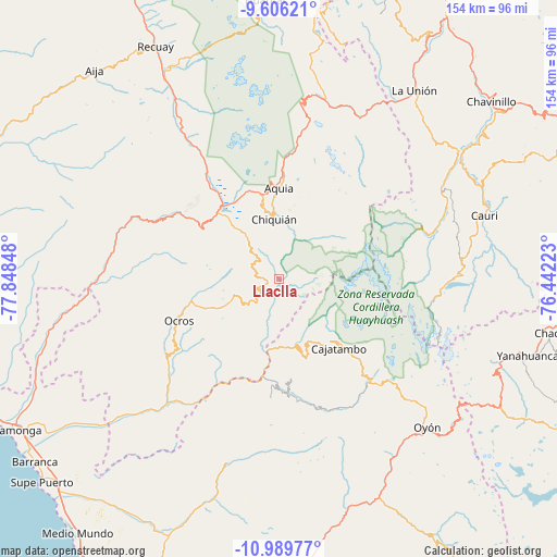
Llaclla GPS coordinates[2]
10° 17' 55.5" South, 77° 8' 43.26" West
| Map corner | latitude | longitude |
|---|---|---|
| Upper-left | -9.60621°, | -77.84848° |
| Center: | -10.29875°, | -77.14535° |
| Lower-right: | -10.98977°, | -76.44223° |
| Map W x H: | 153.8×153.8 km | = 95.6×95.6mi |
| max Lat: | -0.96667° ⇑40.9% North |
| Llaclla: | -10.29875° |
| min Lat: | ⇓59.1% South -18.01465° |
| min Long | Llaclla | max Long |
| -81.30472° | -77.14535° | -69.04167° |
| W 31.2%⇐ | ⇒68.8% E |
Elevation
Elevation of Llaclla is 2094 m = 6870 ft, and this is 224.7 m = 737 ft below average elevation for this country.
| Max E: |
5022 m = 16476 ft | 64.6% |
| Avg. | 2318.7 m = 7607 ft | |
| Llaclla | 2094 m = 6870 ft | |
Min E: |
1 m = 3 ft | 35.4% |
See also: Peru elevation on elevation.city.
Geographical zone
Llaclla is located in South Torrid zone (between Equator and Tropic of Capricorn). Distance of Equator is 1145.1 km =711.5 mi to North.| Distance of | km | miles | from Llaclla |
|---|---|---|---|
| Equator | 1145.1 | 711.5 | to North |
| Tropic Capricorn | 1460.8 | 907.7 | to South |
| Antarctic Circle | 6256.1 | 3887.4 | to South |
| South Pole | 8861.9 | 5506.5 | to South |


Nearby cities:
15 places around Llaclla: (largest is in red/bold)
• Acas
26.6 km =16.5 mi,  228°
228°
• Aco
24.4 km =15.2 mi,  205°
205°
• Aquia
25 km =15.5 mi,  0°
0°
• Cajacay
35.9 km =22.3 mi,  296°
296°
• Canis
5.2 km =3.2 mi, 210°
• Congas
32.7 km =20.3 mi,  262°
262°
• Copa
12.3 km =7.6 mi,  144°
144°
• Corpanqui
6 km =3.7 mi,  284°
284°
• Gorgor
33.9 km =21.1 mi,  158°
158°
• Huasta
19.5 km =12.1 mi,  356°
356°
• Llipa
11.4 km =7.1 mi,  215°
215°
• Mangas
9.6 km =6 mi,  150°
150°
• Ocros
29.8 km =18.5 mi,  247°
247°
• Pampas Chico
34.3 km =21.3 mi,  306°
306°
• Ticllos
7 km =4.3 mi, 314°
Sources, notices
• [Note1] Compared only with cities in Peru existing in our database
• [Src1] Map data: © OpenStreetMap contributors (CC-BY-SA)
• [Src2] Other city data from geonames.org with taken over terms of usage.
• [Src3] Geographical zone / Annual Mean Temperature by Robert A. Rohde @ Wikipedia
