Chamaca geodata
Chamaca (Cusco) is a seat of a third-order administrative division; located in Peru in America/Lima (GMT-5) time zone. In our database, there are 305 cities with bigger population. Compared to other cities in Peru, 80.3% of cities are located further ↑North; 82.1% of cities are located further ←West and 87.6% of cities have lower elevation than Chamaca. Note1


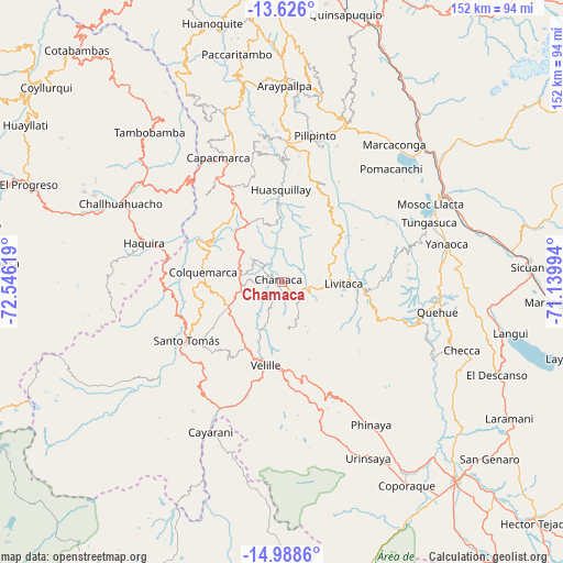
Chamaca GPS coordinates[2]
14° 18' 29.988" South, 71° 50' 35.016" West
| Map corner | latitude | longitude |
|---|---|---|
| Upper-left | -13.626°, | -72.54619° |
| Center: | -14.30833°, | -71.84306° |
| Lower-right: | -14.9886°, | -71.13994° |
| Map W x H: | 151.5×151.5 km | = 94.1×94.1mi |
| max Lat: | -0.96667° ⇑80.3% North |
| Chamaca: | -14.30833° |
| min Lat: | ⇓19.7% South -18.01465° |
| min Long | Chamaca | max Long |
| -81.30472° | -71.84306° | -69.04167° |
| W 82.1%⇐ | ⇒17.9% E |
Elevation
Elevation of Chamaca is 3787 m = 12425 ft, and this is 1468.3 m = 4817 ft above average elevation for this country.
| Max E: |
5022 m = 16476 ft | 12.4% |
| Chamaca | 3787 m 12425 ft | |
| Avg. | 2318.7 m = 7607 ft | |
Min E: |
1 m = 3 ft | 87.6% |
See also: Peru elevation on elevation.city.
Geographical zone
Chamaca is located in South Torrid zone (between Equator and Tropic of Capricorn). Distance of this Southern Tropic circle is 1015 km =630.7 mi to South.| Distance of | km | miles | from Chamaca |
|---|---|---|---|
| Equator | 1590.9 | 988.5 | to North |
| Tropic Capricorn | 1015 | 630.7 | to South |
| Antarctic Circle | 5810.2 | 3610.3 | to South |
| South Pole | 8416.1 | 5229.5 | to South |


Nearby cities:
15 places around Chamaca: (largest is in red/bold)
• Accha
37.2 km =23.1 mi,  2°
2°
• Acos
41.4 km =25.7 mi,  16°
16°
• Cahuanuyo
41.1 km =25.5 mi,  95°
95°
• Capacmarca
37.3 km =23.2 mi,  333°
333°
• Ccaquiracunca
42.5 km =26.4 mi,  85°
85°
• Colquemarca
21.6 km =13.4 mi,  277°
277°
• Haquira
38.9 km =24.2 mi,  285°
285°
• Livitaca
16.8 km =10.4 mi, 87°
• Llusco
29.4 km =18.3 mi,  265°
265°
• Mara
37.8 km =23.5 mi,  310°
310°
• Omacha
28.6 km =17.8 mi, 22°
• Pillpinto
40.4 km =25.1 mi,  12°
12°
• Quiñota
31.6 km =19.6 mi, 270°
• Santo Tomas
30.1 km =18.7 mi,  239°
239°
• Velille
22.8 km =14.2 mi,  191°
191°
Sources, notices
• [Note1] Compared only with cities in Peru existing in our database
• [Src1] Map data: © OpenStreetMap contributors (CC-BY-SA)
• [Src2] Other city data from geonames.org with taken over terms of usage.
• [Src3] Geographical zone / Annual Mean Temperature by Robert A. Rohde @ Wikipedia
