Ayna geodata
Ayna (Ayacucho) is a populated place; located in Peru in America/Lima (GMT-5) time zone. With population of 4,588 people, there are 243 cities with bigger population in this country. Compared to other cities in Peru, 58.4% of cities are located further ↑North; 66.6% of cities are located further ←West and 66.5% of cities have higher elevation than Ayna. Note1


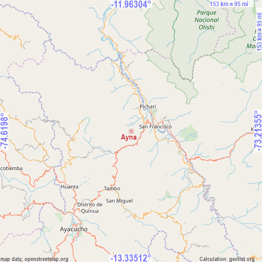
Ayna GPS coordinates[2]
12° 39' 0" South, 73° 55' 0.012" West
| Map corner | latitude | longitude |
|---|---|---|
| Upper-left | -11.96304°, | -74.6198° |
| Center: | -12.65°, | -73.91667° |
| Lower-right: | -13.33512°, | -73.21355° |
| Map W x H: | 152.6×152.6 km | = 94.8×94.8mi |
| max Lat: | -0.96667° ⇑58.4% North |
| Ayna: | -12.65° |
| min Lat: | ⇓41.6% South -18.01465° |
| min Long | Ayna | max Long |
| -81.30472° | -73.91667° | -69.04167° |
| W 66.6%⇐ | ⇒33.4% E |
Elevation
Elevation of Ayna is 1921 m = 6302 ft, and this is 397.7 m = 1305 ft below average elevation for this country.
| Max E: |
5022 m = 16476 ft | 66.5% |
| Avg. | 2318.7 m = 7607 ft | |
| Ayna | 1921 m = 6302 ft | |
Min E: |
1 m = 3 ft | 33.5% |
See also: Peru elevation on elevation.city.
Geographical zone
Ayna is located in South Torrid zone (between Equator and Tropic of Capricorn). Distance of this Southern Tropic circle is 1199.4 km =745.3 mi to South.| Distance of | km | miles | from Ayna |
|---|---|---|---|
| Equator | 1406.5 | 874 | to North |
| Tropic Capricorn | 1199.4 | 745.3 | to South |
| Antarctic Circle | 5994.6 | 3724.9 | to South |
| South Pole | 8600.5 | 5344.1 | to South |


Nearby cities:
15 places around Ayna: (largest is in red/bold)
• Chilcas
58 km =36 mi,  178°
178°
• Churcampa
52.7 km =32.7 mi,  263°
263°
• Huamanguilla
49.1 km =30.5 mi,  215°
215°
• Huanta
47.9 km =29.8 mi,  228°
228°
• Locroja
56.2 km =34.9 mi,  266°
266°
• Luricocha
44 km =27.3 mi,  239°
239°
• Macachacra
48.1 km =29.9 mi, 219°
• Marcas
56.9 km =35.4 mi, 242°
• Mayocc
54.5 km =33.9 mi,  254°
254°
• Pacaycasa
55.5 km =34.5 mi, 215°
• Pichari
19.9 km =12.4 mi,  33°
33°
• Quinua
50.5 km =31.4 mi,  208°
208°
• San Francisco
12.2 km =7.6 mi,  62°
62°
• San Miguel
40.9 km =25.4 mi,  189°
189°
• Tambo
33.3 km =20.7 mi,  198°
198°
Sources, notices
• [Note1] Compared only with cities in Peru existing in our database
• [Src1] Map data: © OpenStreetMap contributors (CC-BY-SA)
• [Src2] Other city data from geonames.org with taken over terms of usage.
• [Src3] Geographical zone / Annual Mean Temperature by Robert A. Rohde @ Wikipedia
