San Miguel geodata
San Miguel (Ayacucho) is a seat of a second-order administrative division; located in Peru in America/Lima (GMT-5) time zone. With population of 8,400 people, there are 165 cities with bigger population in this country. Compared to other cities in Peru, 61.4% of cities are located further ↑North; 66% of cities are located further ←West and 55.3% of cities have higher elevation than San Miguel. Note1


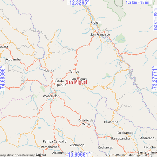
San Miguel GPS coordinates[2]
13° 0' 45" South, 73° 58' 50.988" West
| Map corner | latitude | longitude |
|---|---|---|
| Upper-left | -12.3265°, | -74.68396° |
| Center: | -13.0125°, | -73.98083° |
| Lower-right: | -13.69661°, | -73.27771° |
| Map W x H: | 152.3×152.3 km | = 94.6×94.6mi |
| max Lat: | -0.96667° ⇑61.4% North |
| San Miguel: | -13.0125° |
| min Lat: | ⇓38.6% South -18.01465° |
| min Long | San Miguel | max Long |
| -81.30472° | -73.98083° | -69.04167° |
| W 66%⇐ | ⇒34% E |
Elevation
Elevation of San Miguel is 2667 m = 8750 ft, and this is 348.3 m = 1143 ft above average elevation for this country.
| Max E: |
5022 m = 16476 ft | 55.3% |
| San Miguel | 2667 m 8750 ft | |
| Avg. | 2318.7 m = 7607 ft | |
Min E: |
1 m = 3 ft | 44.7% |
See also: Peru elevation on elevation.city.
Geographical zone
San Miguel is located in South Torrid zone (between Equator and Tropic of Capricorn). Distance of this Southern Tropic circle is 1159.1 km =720.2 mi to South.| Distance of | km | miles | from San Miguel |
|---|---|---|---|
| Equator | 1446.9 | 899.1 | to North |
| Tropic Capricorn | 1159.1 | 720.2 | to South |
| Antarctic Circle | 5954.3 | 3699.8 | to South |
| South Pole | 8560.2 | 5319.1 | to South |


Nearby cities:
15 places around San Miguel: (largest is in red/bold)
• Acocro
23.8 km =14.8 mi,  196°
196°
• Ayacucho
30.9 km =19.2 mi,  238°
238°
• Carmen Alto
32.5 km =20.2 mi,  234°
234°
• Chiara
37.8 km =23.5 mi,  219°
219°
• Chilcas
19.4 km =12.1 mi,  155°
155°
• Huamanguilla
21.4 km =13.3 mi,  270°
270°
• Huanta
30.5 km =19 mi,  286°
286°
• Luricocha
35.9 km =22.3 mi,  300°
300°
• Macachacra
24 km =14.9 mi,  277°
277°
• Pacaycasa
25.7 km =16 mi,  258°
258°
• Pampas
25.8 km =16 mi, 158°
• Quinua
17.6 km =10.9 mi, 256°
• Socos
40.3 km =25 mi, 236°
• Tambillo
24.5 km =15.2 mi, 215°
• Tambo
9.6 km =6 mi,  336°
336°
Sources, notices
• [Note1] Compared only with cities in Peru existing in our database
• [Src1] Map data: © OpenStreetMap contributors (CC-BY-SA)
• [Src2] Other city data from geonames.org with taken over terms of usage.
• [Src3] Geographical zone / Annual Mean Temperature by Robert A. Rohde @ Wikipedia
