Acocro geodata
Acocro (Ayacucho) is a seat of a third-order administrative division; located in Peru in America/Lima (GMT-5) time zone. In our database, there are 305 cities with bigger population. Compared to other cities in Peru, 63.3% of cities are located further ↑North; 65.6% of cities are located further ←West and 64.6% of cities have lower elevation than Acocro. Note1


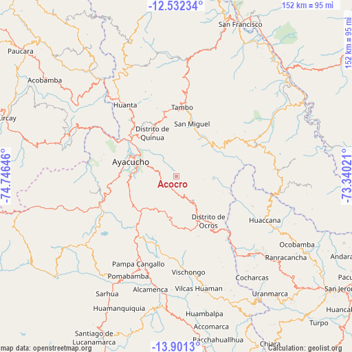
Acocro GPS coordinates[2]
13° 13' 4.008" South, 74° 2' 35.988" West
| Map corner | latitude | longitude |
|---|---|---|
| Upper-left | -12.53234°, | -74.74646° |
| Center: | -13.21778°, | -74.04333° |
| Lower-right: | -13.9013°, | -73.34021° |
| Map W x H: | 152.2×152.2 km | = 94.6×94.6mi |
| max Lat: | -0.96667° ⇑63.3% North |
| Acocro: | -13.21778° |
| min Lat: | ⇓36.7% South -18.01465° |
| min Long | Acocro | max Long |
| -81.30472° | -74.04333° | -69.04167° |
| W 65.6%⇐ | ⇒34.4% E |
Elevation
Elevation of Acocro is 3251 m = 10666 ft, and this is 932.3 m = 3059 ft above average elevation for this country.
| Max E: |
5022 m = 16476 ft | 35.4% |
| Acocro | 3251 m 10666 ft | |
| Avg. | 2318.7 m = 7607 ft | |
Min E: |
1 m = 3 ft | 64.6% |
See also: Peru elevation on elevation.city.
Geographical zone
Acocro is located in South Torrid zone (between Equator and Tropic of Capricorn). Distance of this Southern Tropic circle is 1136.2 km =706 mi to South.| Distance of | km | miles | from Acocro |
|---|---|---|---|
| Equator | 1469.7 | 913.2 | to North |
| Tropic Capricorn | 1136.2 | 706 | to South |
| Antarctic Circle | 5931.5 | 3685.7 | to South |
| South Pole | 8537.4 | 5304.9 | to South |


Nearby cities:
15 places around Acocro: (largest is in red/bold)
• Ayacucho
20.5 km =12.7 mi,  288°
288°
• Carmen Alto
20 km =12.4 mi,  281°
281°
• Chiara
18.5 km =11.5 mi,  250°
250°
• Chilcas
15.6 km =9.7 mi,  70°
70°
• Huamanguilla
27.2 km =16.9 mi,  327°
327°
• Macachacra
31.1 km =19.3 mi, 326°
• Ocros
23.8 km =14.8 mi,  144°
144°
• Pacaycasa
25.7 km =16 mi,  314°
314°
• Pampas
16.2 km =10.1 mi,  94°
94°
• Quinua
21.4 km =13.3 mi, 331°
• San Miguel
23.8 km =14.8 mi,  16°
16°
• Socos
26.6 km =16.5 mi,  270°
270°
• Tambillo
7.9 km =4.9 mi, 291°
• Tambo
31.8 km =19.8 mi,  5°
5°
• Ticllas
32.7 km =20.3 mi, 286°
Sources, notices
• [Note1] Compared only with cities in Peru existing in our database
• [Src1] Map data: © OpenStreetMap contributors (CC-BY-SA)
• [Src2] Other city data from geonames.org with taken over terms of usage.
• [Src3] Geographical zone / Annual Mean Temperature by Robert A. Rohde @ Wikipedia
