Chugay geodata
Chugay (La Libertad) is a seat of a third-order administrative division; located in Peru in America/Lima (GMT-5) time zone. In our database, there are 305 cities with bigger population. Compared to other cities in Peru, 75.2% of cities are located further ↓South; 78.9% of cities are located further →East and 71.9% of cities have lower elevation than Chugay. Note1


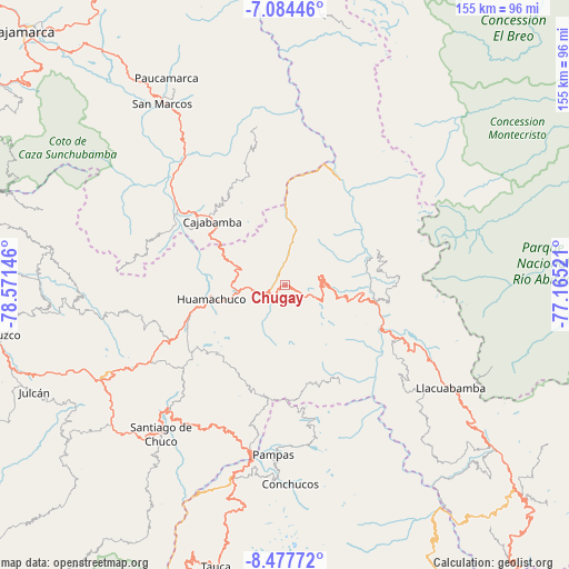
Chugay GPS coordinates[2]
7° 46' 54.012" South, 77° 52' 5.988" West
| Map corner | latitude | longitude |
|---|---|---|
| Upper-left | -7.08446°, | -78.57146° |
| Center: | -7.78167°, | -77.86833° |
| Lower-right: | -8.47772°, | -77.16521° |
| Map W x H: | 154.9×154.9 km | = 96.3×96.3mi |
| max Lat: | -0.96667° ⇑24.8% North |
| Chugay: | -7.78167° |
| min Lat: | ⇓75.2% South -18.01465° |
| min Long | Chugay | max Long |
| -81.30472° | -77.86833° | -69.04167° |
| W 21.1%⇐ | ⇒78.9% E |
Elevation
Elevation of Chugay is 3381 m = 11093 ft, and this is 1062.3 m = 3485 ft above average elevation for this country.
| Max E: |
5022 m = 16476 ft | 28.1% |
| Chugay | 3381 m 11093 ft | |
| Avg. | 2318.7 m = 7607 ft | |
Min E: |
1 m = 3 ft | 71.9% |
See also: Peru elevation on elevation.city.
Geographical zone
Chugay is located in South Torrid zone (between Equator and Tropic of Capricorn). Distance of Equator is 865.2 km =537.6 mi to North.| Distance of | km | miles | from Chugay |
|---|---|---|---|
| Equator | 865.2 | 537.6 | to North |
| Tropic Capricorn | 1740.7 | 1081.6 | to South |
| Antarctic Circle | 6535.9 | 4061.2 | to South |
| South Pole | 9141.8 | 5680.4 | to South |


Nearby cities:
15 places around Chugay: (largest is in red/bold)
• Angasmarca
44.8 km =27.8 mi,  209°
209°
• Aricapampa
16.9 km =10.5 mi,  99°
99°
• Cajabamba
27.2 km =16.9 mi,  312°
312°
• Cauday
32.4 km =20.1 mi, 312°
• Curgos
12 km =7.5 mi,  223°
223°
• Huamachuco
21.9 km =13.6 mi,  264°
264°
• La Grama
45.6 km =28.3 mi,  320°
320°
• Lluchubamba
31 km =19.3 mi,  338°
338°
• Marcabal
20.3 km =12.6 mi,  296°
296°
• Mollepata
47.4 km =29.5 mi,  190°
190°
• Pampas
46.6 km =29 mi,  184°
184°
• Parcoy
51.2 km =31.8 mi,  123°
123°
• Quiruvilca
41.9 km =26 mi,  240°
240°
• Sartimbamba
16.5 km =10.3 mi,  56°
56°
• Sitabamba
31.7 km =19.7 mi,  152°
152°
Sources, notices
• [Note1] Compared only with cities in Peru existing in our database
• [Src1] Map data: © OpenStreetMap contributors (CC-BY-SA)
• [Src2] Other city data from geonames.org with taken over terms of usage.
• [Src3] Geographical zone / Annual Mean Temperature by Robert A. Rohde @ Wikipedia
