Llata geodata
Llata (Huanuco) is a seat of a third-order administrative division; located in Peru in America/Lima (GMT-5) time zone. In our database, there are 305 cities with bigger population. Compared to other cities in Peru, 64.2% of cities are located further ↓South; 65% of cities are located further →East and 75.2% of cities have lower elevation than Llata. Note1


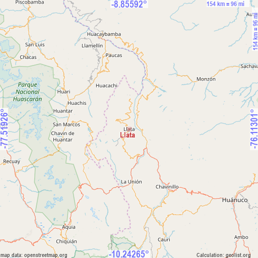
Llata GPS coordinates[2]
9° 32' 59.964" South, 76° 48' 58.068" West
| Map corner | latitude | longitude |
|---|---|---|
| Upper-left | -8.85592°, | -77.51926° |
| Center: | -9.54999°, | -76.81613° |
| Lower-right: | -10.24265°, | -76.11301° |
| Map W x H: | 154.2×154.2 km | = 95.8×95.8mi |
| max Lat: | -0.96667° ⇑35.8% North |
| Llata: | -9.54999° |
| min Lat: | ⇓64.2% South -18.01465° |
| min Long | Llata | max Long |
| -81.30472° | -76.81613° | -69.04167° |
| W 35%⇐ | ⇒65% E |
Elevation
Elevation of Llata is 3438 m = 11280 ft, and this is 1119.3 m = 3672 ft above average elevation for this country.
| Max E: |
5022 m = 16476 ft | 24.8% |
| Llata | 3438 m 11280 ft | |
| Avg. | 2318.7 m = 7607 ft | |
Min E: |
1 m = 3 ft | 75.2% |
See also: Peru elevation on elevation.city.
Geographical zone
Llata is located in South Torrid zone (between Equator and Tropic of Capricorn). Distance of Equator is 1061.9 km =659.8 mi to North.| Distance of | km | miles | from Llata |
|---|---|---|---|
| Equator | 1061.9 | 659.8 | to North |
| Tropic Capricorn | 1544.1 | 959.5 | to South |
| Antarctic Circle | 6339.3 | 3939.1 | to South |
| South Pole | 8945.2 | 5558.3 | to South |


Nearby cities:
15 places around Llata: (largest is in red/bold)
• Chuquis
18.7 km =11.6 mi,  138°
138°
• Huacachi
29.3 km =18.2 mi,  332°
332°
• Jacas Grande
8.8 km =5.5 mi,  82°
82°
• Llata
15.3 km =9.5 mi,  13°
13°
• Miraflores
6.2 km =3.9 mi,  357°
357°
• Pachas
18.1 km =11.2 mi,  164°
164°
• Pampamarca
21.3 km =13.2 mi, 144°
• Punchao
9.8 km =6.1 mi, 357°
• Puños
9.5 km =5.9 mi,  307°
307°
• Quivilla
11.4 km =7.1 mi,  118°
118°
• Shunqui
20.7 km =12.9 mi,  170°
170°
• Sillapata
23.6 km =14.7 mi, 168°
• Singa
18.1 km =11.2 mi,  1°
1°
• Tantamayo
20.4 km =12.7 mi,  29°
29°
• Yanas
19.7 km =12.2 mi, 157°
Sources, notices
• [Note1] Compared only with cities in Peru existing in our database
• [Src1] Map data: © OpenStreetMap contributors (CC-BY-SA)
• [Src2] Other city data from geonames.org with taken over terms of usage.
• [Src3] Geographical zone / Annual Mean Temperature by Robert A. Rohde @ Wikipedia
